
filter
-
Brand
- By Category
- Direction
- Date Range
65Events
Pictures
Events
Editorial
- 2023-11-14
- 1
Editorial
- 2023-06-14
- 1

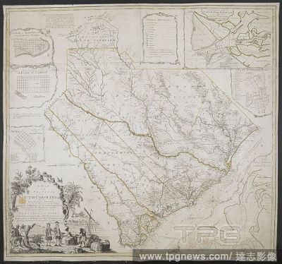
Editorial A Map of the Province of South Carolina. A MAP of the PROVINCE of SOUTH CAROLINA with all the Rivers, Creeks, Bays, Inletts, Islands, INLAND NAVIGATION, Soundings, Time of High Water on the Sea Coast, Roads, Marshes, Ferrys, Bridges, Swamps, Parishes C...
- 2022-12-24
- 1
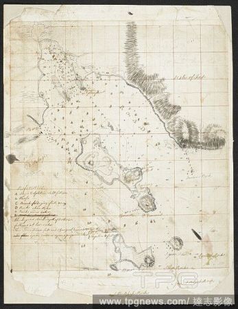
Editorial A plan of the harbour of ST Peters off S. Coast Newfoundland Low water soundings. References to: A. Stagins for splitting & salting fish B. Warfes C. Beach for drying fish(Symbol): rock above water(symbol): rock under water Shows Isle Dogs; Boar I...
- 2022-12-24
- 1

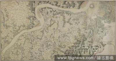
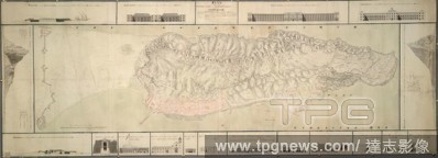
Editorial Quebec Harbour River St. Lawrence to “ A scale of Three Thousand Yards” Shows Island of Orleans, N & S Channels of Orleans and full soundings. . SIXTY-SEVEN Charts and maps illustrating the voyages and surveys of Capt. James Cook, R.N., and other...
- 2022-12-24
- 1
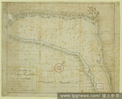
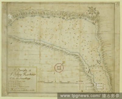
Editorial A plan of St. John's Harbour in Newfoundland, with the soundings. A Draught of St Johns Harbour With the Soundings. [St John's?] : [producer not identified], [1698.]. Source: Maps K.Top.119.103. Language: English.
- 2022-12-24
- 1
Editorial A chart of the province of New England, around 1670. A chart of the province of New England, with the soundings on the coast; drawn about 1670, on a scale of 1 2/3 English league to an inch. About 1670. Ms. 5 f. 8 in. x 2 f. 9 in.; 173 x 84 cm.; Scale ...
- 2022-12-24
- 1

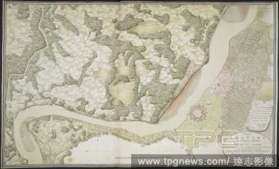
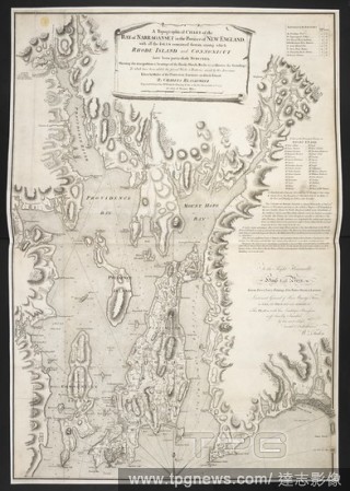
Editorial A topographical chart of the Bay of Narraganset . A Topographical CHART of the BAY of NARRAGANSET in the Province of NEW ENGLAND, with all the ISLES contained therein, among which RHODE ISLAND and CONNONICUT have been particularly SURVEYED. : Shewing t...
- 2022-12-24
- 1
Editorial A "sketch of the bay and islands, north of Lantao, with the soundings;" drawn by H.W. Parish, in 1793, on a scale of 2 2/3 miles to an inch. . A "sketch of the bay and islands, north of Lantao, with the soundings;" drawn by H.W. Parish, in 1793, on a s...
- 2022-01-18
- 1
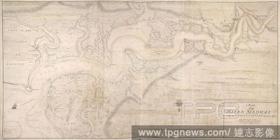
Editorial A plan of the River Medway. A colored plan of the river Medway, with the fortifications thereon, 1725; with the soundings of the river, taken at low water at spring tides; drawn on a scale of 550 yards to an inch. 1725. Source: Maps K.Top.16.31.2. Lang...
- 2022-01-18
- 1
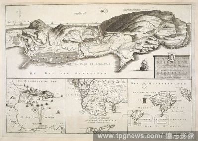
Editorial A plan of Gibraltar and its fortifications. Includes insets of the Bay of Gibraltar with soundings, the Straits of Gibraltar and the Balearic Islands . NIEW EN SEER NAW KEURIC CORECTE PLAN VAN GIBRALTAR met alle syne Fortificatiens en Verbeteringe en d...
- 2022-01-18
- 1

Editorial A survey of the country on the banks of the Hughly River, from the town of Calcutta of Ooloobareah, and which includes the fortress of Fort William and works at Budge Budge. A "survey of the country on the banks of the Hughly River, from the town of Ca...
- 2022-01-18
- 1
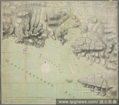
Editorial An ink and watercolour over pencil, unfinished, manuscript map of Cartagena in Murcia. PLAN of the TOWN and HARBOUR of CARTAGENA in the PRIVINCE of MURCIA in OLD SPAIN with Its DOCK YARD and Bason, FORTS and BATTERies as they stood in the Month of Octo...
- 2022-01-18
- 1

Editorial A plan of the isthmus, city and fortifications of Gibraltar. A colored "plan of the isthmus, city, and fortifications of Gibraltar, shewing elevations and sections of the principal public buildings, profiles through the two extremities of the rock, and...
- 2022-01-18
- 1
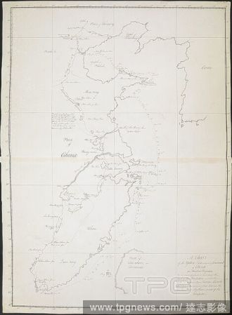
Editorial "A chart of the Yellow Sea and part of the Continent of China (on Mercator's projection); in the former of which is laid down the tract of the Hindostan and Lion for every day by the chronometer, and the soundings from the streight of Formosa, to the l...
- 2022-01-18
- 1
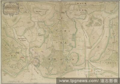
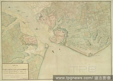
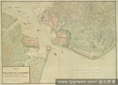
Editorial A survey of Portsea Island. A colored survey of Portsea Island, shewing the towns and fortifications of Portsmouth and Gosport, the dock, Blockhouse Fort, Portsmouth and Langston harbours, with the castles, islands, channels, sands, etc., in and about ...
- 2022-01-18
- 1
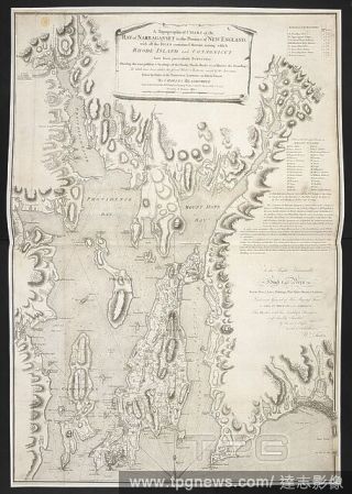
Editorial A topographical chart of the Bay of Narraganset . A Topographical CHART of the BAY of NARRAGANSET in the Province of NEW ENGLAND, with all the ISLES contained therein, among which RHODE ISLAND and CONNONICUT have been particularly SURVEYED. : Shewing t...
- 2022-01-18
- 1

Editorial A plan of the Island of Portsea. A colored plan of the Island of Portsea, shewing the present fortifications of Portsmouth, Gosport, lines and out forts, together with the works now carrying on to secure his Majesty's dock-yard; with the intrenchments ...
- 2022-01-18
- 1
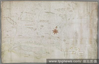
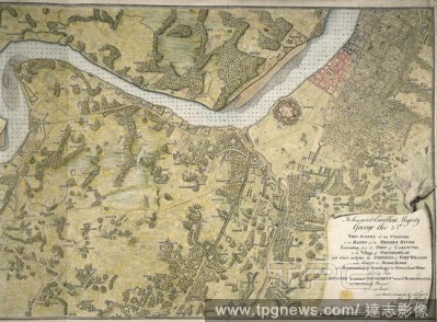
Editorial A Map of the Province of South Carolina. A MAP of the PROVINCE of SOUTH CAROLINA with all the Rivers, Creeks, Bays, Inletts, Islands, INLAND NAVIGATION, Soundings, Time of High Water on the Sea Coast, Roads, Marshes, Ferrys, Bridges, Swamps, Parishes C...
- 2022-01-18
- 1
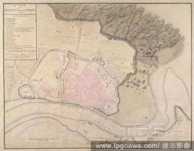
Editorial A plan of Berwick upon Tweed. A colored plan of Berwick upon Tweed, shewing the old fortifications demolished and the boundaries of the king's land, with the soundings of the harbour at low water. 1725. Source: Maps K.Top.32.46. Language: English.
- 2022-01-18
- 1

Editorial A plan of the harbour of ST Peters off S. Coast Newfoundland Low water soundings. References to: A. Stagins for splitting & salting fish B. Warfes C. Beach for drying fish(Symbol): rock above water(symbol): rock under water Shows Isle Dogs; Boar I...
- 2022-01-18
- 1
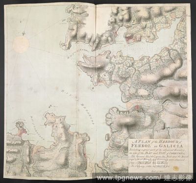
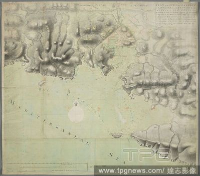
Editorial An ink and watercolour manuscript map of the coastline between Ferrol and Coru?a in Galicia . A PLAN of the HARBOUR of FERROL in GALICIA. Including a great part of the adjacent Country, as also of the BAY and CITY of CORRUGNA : The Ground Sketched upo...
- 2022-01-18
- 1
Editorial A survey of the country on the eastern bank of the Hughly, from Calcutta to the Fortifications at Budgebudge, including Fort William and the Post at Manicolly Point. A "survey of the country on the eastern bank of the Hughly, from Calcutta to the Forti...
- 2022-01-18
- 1

Editorial A map of the coast of Spain, and two insets with soundings: "The Bay & City of Gibraltar in Spain" and "The Harbour of Port Mahon" . A MAP of the Coast of SPAIN, from the Streights of GIBRALTAR; to the Gulf of CARTAGENA. London : Sold by by H: Overton ...
- 2022-01-18
- 1

Editorial A survey of the country on the banks of the Hughly, from Manicolly Point to Chitpore. A "survey of the country on the banks of the Hughly, from Manicolly Point to Chitpore, including the Post at Manicolly, Fort William, and the town of Calcutta, and sh...
- 2022-01-18
- 1
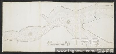
Editorial Quebec Harbour River St. Lawrence to “ A scale of Three Thousand Yards” Shows Island of Orleans, N & S Channels of Orleans and full soundings. . SIXTY-SEVEN Charts and maps illustrating the voyages and surveys of Capt. James Cook, R.N., and other...
- 2022-01-18
- 1
Editorial A plan of Portsmouth, Portsea, Gosport, South Sea Castle and parts adjacent. A colored plan of Portsmouth, Portsea, Gosport, South Sea Castle, and parts adjacent, shewing the intended fortifications not yet completed; by John P. Desmaretz, 1750; with t...
- 2022-01-18
- 1
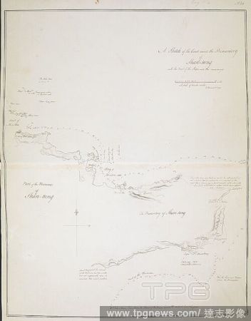
Editorial A "sketch of the coast round the Promontory of Shan-tung," from Cape Macartney to Teu-tcheou-foo head, taken by compass in sailing round it; with the track of the Lion and Hindostan, and the soundings; drawn by J. Barrow in 1793. . A collection of eigh...
- 2022-01-18
- 1

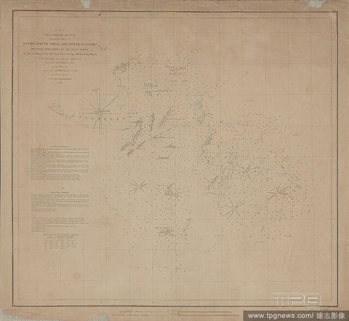
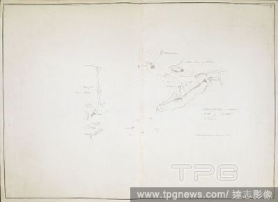
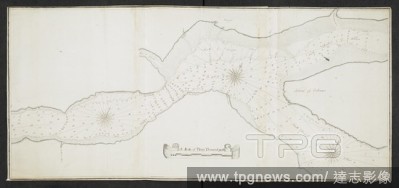
Editorial Preliminary sketch showing the positions of Davis's South Shoal and other dangers recently discovered by the Coast Survey and the soundings on the Old South Shoal, Bass Rip, Old Man, Pochinck Rip, &c., cartographic, Maps, 1852, Davis, Charles Henry, 18...
- 2021-02-22
- 2
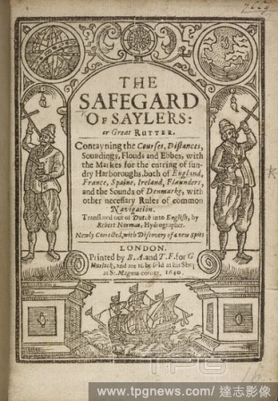
Editorial Title page of 'The Safegarde of Saylers, or great Rutter...'. The Safegarde of Saylers, or great Rutter. Contayning the courses, dystances, deapths, soundings, flouds and ebbes, with the marks for the entring of sundry harboroughs both of England, Frau...
- 2020-12-04
- 1
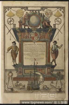
Editorial Engraved frontispiece to Mariner's Mirrour . The Mariners Mirrour, wherin [sic] may playnly be seen the courses, heights, distances, depths, soundings, flouds, and ebs with the marks for th'entrings of the Harbouroughs, Havens and Ports of the greatest...
- 2020-12-04
- 1

Editorial THE AMERICAN CENTENNIAL EXHIBITION: NOTES ON THE WAY TO PHILADELPHIA, 1876; AN ATLANTIC SWELL, MUSIC IN THE BOWS, THE KITCHEN, ON SOUNDINGS.
- 2020-12-01
- 1

Editorial Engraved frontispiece to Mariner's Mirrour . The Mariners Mirrour, wherin [sic] may playnly be seen the courses, heights, distances, depths, soundings, flouds, and ebs with the marks for th'entrings of the Harbouroughs, Havens and Ports of the greatest...
- 2020-09-29
- 1

Editorial "A chart of the Yellow Sea and part of the Continent of China (on Mercator's projection); in the former of which is laid down the tract of the Hindostan and Lion for every day by the chronometer, and the soundings from the streight of Formosa, to the l...
- 2020-09-28
- 1
Editorial Arderseer and Channary. A colored survey of the points of Arderseer and Ch. 1752. A colored survey of the points of Arderseer and Channary, in the Murray Firth, shewing the situation of Fort George, and the soundings of the channel. Image taken from A...
- 2019-01-24
- 1
Editorial A plan of soundings. [A Plan of Soundings from Pulo Aor to the Southwar. London, 1812. Source: Maps.60001.(6),. Language: English.
- 2019-01-24
- 1
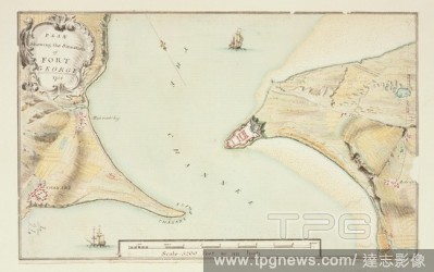
Editorial Plan of Fort George. A colored survey of the points of Arderseer and Ch. 1752. A plan showing the situation of Fort George. Image taken from A colored survey of the points of Arderseer and Channary, in the Murray Firth, shewing the situation of Fort G...
- 2018-12-06
- 1
Editorial A plan of the Island of Portsea. A colored plan of the Island of Portsea, shewing the present fortifications of Portsmouth, Gosport, lines and out forts, together with the works now carrying on to secure his Majesty's dock-yard; with the intrenchments ...
- 2018-12-06
- 1
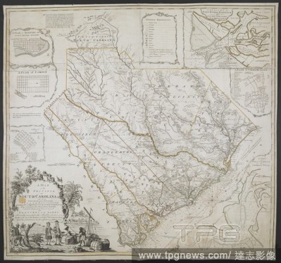
Editorial A Map of the Province of South Carolina. A MAP of the PROVINCE of SOUTH CAROLINA with all the Rivers, Creeks, Bays, Inletts, Islands, INLAND NAVIGATION, Soundings, Time of High Water on the Sea Coast, Roads, Marshes, Ferrys, Bridges, Swamps, Parishes C...
- 2018-12-06
- 1
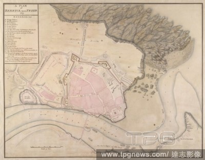
Editorial A plan of Berwick upon Tweed. A colored plan of Berwick upon Tweed, shewing the old fortifications demolished and the boundaries of the king's land, with the soundings of the harbour at low water. 1725. Source: Maps K.Top.32.46. Language: English.
- 2018-12-06
- 1

Editorial A plan of the harbour of ST Peters off S. Coast Newfoundland Low water soundings. References to: A. Stagins for splitting & salting fish B. Warfes C. Beach for drying fish(Symbol): rock above water(symbol): rock under water Shows Isle Dogs; Boar I...
- 2018-12-06
- 1

Editorial An ink and watercolour manuscript map of the coastline between Ferrol and Coru?a in Galicia . A PLAN of the HARBOUR of FERROL in GALICIA. Including a great part of the adjacent Country, as also of the BAY and CITY of CORRUGNA : The Ground Sketched upo...
- 2018-12-06
- 1

Editorial Title page of 'The Safegarde of Saylers, or great Rutter...'. The Safegarde of Saylers, or great Rutter. Contayning the courses, dystances, deapths, soundings, flouds and ebbes, with the marks for the entring of sundry harboroughs both of England, Frau...
- 2018-12-06
- 1

Editorial A "sketch of the bay and islands, north of Lantao, with the soundings;" drawn by H.W. Parish, in 1793, on a scale of 2 2/3 miles to an inch. . A "sketch of the bay and islands, north of Lantao, with the soundings;" drawn by H.W. Parish, in 1793, on a s...
- 2018-12-06
- 1

Editorial Engraved frontispiece to Mariner's Mirrour . The Mariners Mirrour, wherin [sic] may playnly be seen the courses, heights, distances, depths, soundings, flouds, and ebs with the marks for th'entrings of the Harbouroughs, Havens and Ports of the greatest...
- 2018-12-06
- 1
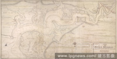
Editorial A plan of the River Medway. A colored plan of the river Medway, with the fortifications thereon, 1725; with the soundings of the river, taken at low water at spring tides; drawn on a scale of 550 yards to an inch. 1725. Source: Maps K.Top.16.31.2. Lang...
- 2018-12-06
- 1

Editorial A plan of Gibraltar and its fortifications. Includes insets of the Bay of Gibraltar with soundings, the Straits of Gibraltar and the Balearic Islands . NIEW EN SEER NAW KEURIC CORECTE PLAN VAN GIBRALTAR met alle syne Fortificatiens en Verbeteringe en d...
- 2018-12-06
- 1
Editorial A survey of the country on the banks of the Hughly River, from the town of Calcutta of Ooloobareah, and which includes the fortress of Fort William and works at Budge Budge. A "survey of the country on the banks of the Hughly River, from the town of Ca...
- 2018-12-06
- 1

Editorial A survey of the country on the eastern bank of the Hughly, from Calcutta to the Fortifications at Budgebudge, including Fort William and the Post at Manicolly Point. A "survey of the country on the eastern bank of the Hughly, from Calcutta to the Forti...
- 2018-12-06
- 1

Editorial A map of the coast of Spain, and two insets with soundings: "The Bay & City of Gibraltar in Spain" and "The Harbour of Port Mahon" . A MAP of the Coast of SPAIN, from the Streights of GIBRALTAR; to the Gulf of CARTAGENA. London : Sold by by H: Overton ...
- 2018-12-06
- 1
Editorial A survey of the country on the banks of the Hughly, from Manicolly Point to Chitpore. A "survey of the country on the banks of the Hughly, from Manicolly Point to Chitpore, including the Post at Manicolly, Fort William, and the town of Calcutta, and sh...
- 2018-12-06
- 1
Editorial Quebec Harbour River St. Lawrence to “ A scale of Three Thousand Yards” Shows Island of Orleans, N & S Channels of Orleans and full soundings. . SIXTY-SEVEN Charts and maps illustrating the voyages and surveys of Capt. James Cook, R.N., and other...
- 2018-12-06
- 1

Editorial Arderseer and Channary. A colored survey of the points of Arderseer and Ch. 1752. A colored survey of the points of Arderseer and Channary, in the Murray Firth, shewing the situation of Fort George, and the soundings of the channel. Image taken from A...
- 2018-12-06
- 1
Editorial A plan of Portsmouth, Portsea, Gosport, South Sea Castle and parts adjacent. A colored plan of Portsmouth, Portsea, Gosport, South Sea Castle, and parts adjacent, shewing the intended fortifications not yet completed; by John P. Desmaretz, 1750; with t...
- 2018-12-06
- 1

Editorial A "sketch of the coast round the Promontory of Shan-tung," from Cape Macartney to Teu-tcheou-foo head, taken by compass in sailing round it; with the track of the Lion and Hindostan, and the soundings; drawn by J. Barrow in 1793. . A collection of eigh...
- 2018-12-06
- 1

Editorial A plan of soundings. [A Plan of Soundings from Pulo Aor to the Southwar. London, 1812. Source: Maps.60001.(6),. Language: English.
- 2018-12-06
- 1
Editorial An ink and watercolour over pencil, unfinished, manuscript map of Cartagena in Murcia. PLAN of the TOWN and HARBOUR of CARTAGENA in the PRIVINCE of MURCIA in OLD SPAIN with Its DOCK YARD and Bason, FORTS and BATTERies as they stood in the Month of Octo...
- 2018-12-06
- 1
Editorial A plan of the isthmus, city and fortifications of Gibraltar. A colored "plan of the isthmus, city, and fortifications of Gibraltar, shewing elevations and sections of the principal public buildings, profiles through the two extremities of the rock, and...
- 2018-12-06
- 1

Editorial "A chart of the Yellow Sea and part of the Continent of China (on Mercator's projection); in the former of which is laid down the tract of the Hindostan and Lion for every day by the chronometer, and the soundings from the streight of Formosa, to the l...
- 2018-12-06
- 1
Editorial A plan of St. John's Harbour in Newfoundland, with the soundings. A Draught of St Johns Harbour With the Soundings. [St John's?] : [producer not identified], [1698.]. Source: Maps K.Top.119.103. Language: English.
- 2018-12-06
- 1

Editorial A chart of the province of New England, around 1670. A chart of the province of New England, with the soundings on the coast; drawn about 1670, on a scale of 1 2/3 English league to an inch. About 1670. Ms. 5 f. 8 in. x 2 f. 9 in.; 173 x 84 cm.; Scale ...
- 2018-12-06
- 1
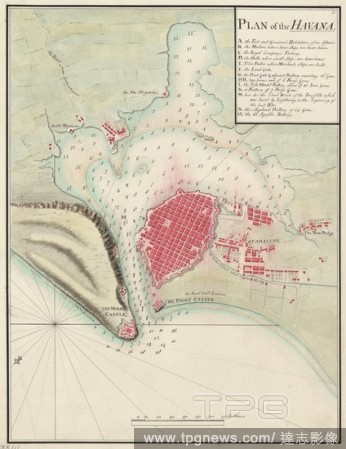
Editorial Plan of the Havana. A plan of the Havana, with the soundings of the ha. c.1800. Plan of the Havana. Image taken from A plan of the Havana, with the soundings of the harbour; drawn about 1800, on a scale of 240 fathoms to an inch. Originally published...
- 2018-12-06
- 1
Editorial A survey of Portsea Island. A colored survey of Portsea Island, shewing the towns and fortifications of Portsmouth and Gosport, the dock, Blockhouse Fort, Portsmouth and Langston harbours, with the castles, islands, channels, sands, etc., in and about ...
- 2018-12-06
- 1
Editorial A topographical chart of the Bay of Narraganset . A Topographical CHART of the BAY of NARRAGANSET in the Province of NEW ENGLAND, with all the ISLES contained therein, among which RHODE ISLAND and CONNONICUT have been particularly SURVEYED. : Shewing t...
- 2018-12-06
- 1

Editorial THE AMERICAN CENTENNIAL EXHIBITION: NOTES ON THE WAY TO PHILADELPHIA, 1876; AN ATLANTIC SWELL, MUSIC IN THE BOWS, THE KITCHEN, ON SOUNDINGS.
- 2018-07-27
- 1
 Loading