
filter
-
Brand
- By Category
- Direction
- Date Range
52Events
Pictures
Events
Editorial
- 2023-06-16
- 1
Editorial
- 2023-05-13
- 2
Editorial
- 2023-05-12
- 1

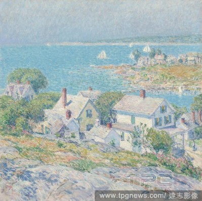
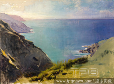
Editorial New England Headlands. Childe Hassam; American, 1859-1935. Date: 1899. Dimensions: 68.9 ? 68.9 cm (27 1/8 ? 27 1/8 in.). Oil on canvas. Origin: Gloucester.
- 2022-12-25
- 1

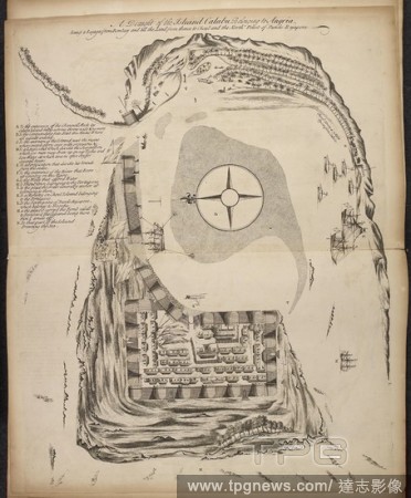
Editorial DRAWINGS, in Indian ink, of headlands, bays, islands, etc., by A. Buchan, draughtsman to Alr. Banks, in Capt. J. Cook's first voyage, 1768-1770.
- 2022-12-24
- 1

Editorial Fog rolls through the Marin Headlands and Golden Gate Bridge in Sausalito, Calif., June 11, 2022. (Nina Riggio/The New York Times)
- 2022-12-16
- 1

Editorial Fog rolls over the Golden Gate Bridge, seen from the Marin Headlands in Sausalito, Calif., June 11, 2022. (Nina Riggio/The New York Times)
- 2022-11-19
- 1

Editorial Fog rolls through the Marin Headlands and Golden Gate Bridge in Sausalito, Calif., June 11, 2022. (Nina Riggio/The New York Times)
- 2022-10-21
- 1

Editorial Fog rolls through the Marin Headlands and Golden Gate Bridge in Sausalito, Calif., June 11, 2022. (Nina Riggio/The New York Times)
- 2022-09-23
- 1
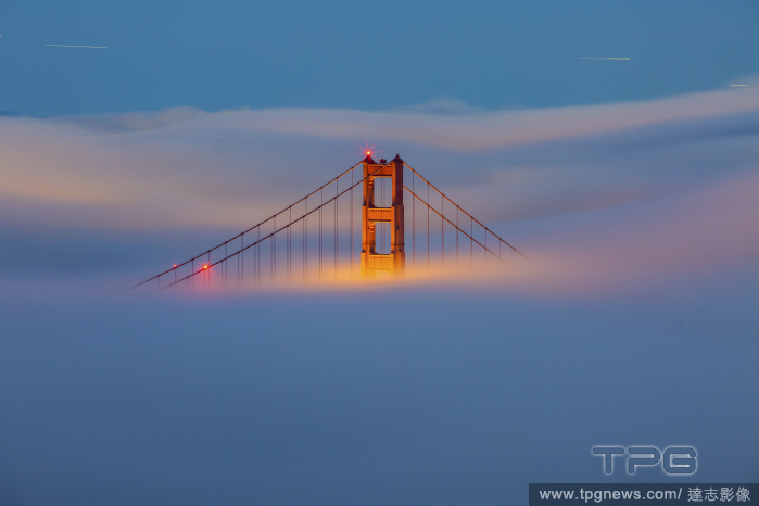
Editorial Fog rolls through the Marin Headlands and Golden Gate Bridge in Sausalito, Calif., June 11, 2022. (Nina Riggio/The New York Times)
- 2022-09-22
- 7

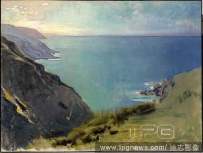
Editorial Cornish Headlands. Date/Period: 1898. Painting. Oil on canvas Oil on canvas. Height: 765.30 mm (30.12 in); Width: 1,019.30 mm (40.12 in).
- 2022-07-21
- 1
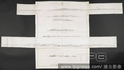
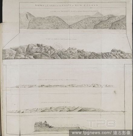
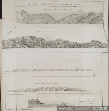
Editorial Various views of headlands on the coasts of New Zealand; drawn by Lieut. James Cook, in his first voyage. Charts, Plans, Views, and Drawings taken on board the Endeavour during Captain Cook's First Voyage, 1768-1771. ca. 1769-1770. Source: Add. 7085, N...
- 2022-01-18
- 1
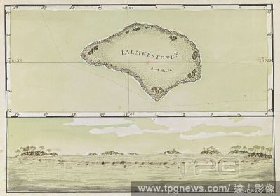
Editorial (Whole Map) Chart of Palmerston Island, with coastal view. Captain Cook reached this small island, near Niue, on 16th June 1774. Charts, and views of headlands, taken during Captain Cook's Second Voyage, 1772-1774. Source: Add. 15500, No.10. Language: ...
- 2022-01-18
- 1
Editorial Various views of headlands on the coasts of New Zealand; drawn by Lieut. James Cook, in his first voyage. Charts, Plans, Views, and Drawings taken on board the Endeavour during Captain Cook's First Voyage, 1768-1771. ca. 1769-1770. Source: Add. 7085, N...
- 2022-01-18
- 1
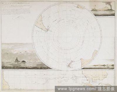
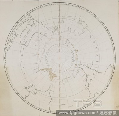
Editorial [Whole map] Map of the southern hemisphere showing the route of the Resolution during Captain Cook's Second Voyage, from Capetown in November 1772, to Caledonia in October 1774. Three coastal views; Resolution Harbour, Frieslands Head and the Sandwich ...
- 2022-01-18
- 1
Editorial Various views of headlands on the coasts of New Zealand; drawn by Lieut. James Cook, in his first voyage. Charts, Plans, Views, and Drawings taken on board the Endeavour during Captain Cook's First Voyage, 1768-1771. ca. 1769-1770. Source: Add. 7085, N...
- 2022-01-18
- 1

Editorial Chart and picture of Savage island. Niue was first seen by Captain James Cook in 1774. He named the island "Savage Island". TWENTY-TWO Charts, views of Headlands, etc., taken during Captain Cook's voyage in the Resolution through the Pacific and South...
- 2022-01-18
- 1
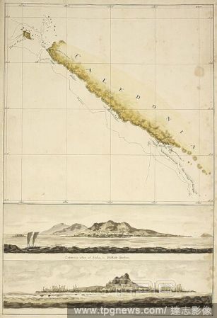
Editorial Map of New Caledonia, with two coastal views; Ballarde Harbour, and the Isle of Pines. October 1774. Charts, and views of headlands, taken during Captain Cook's Second Voyage, 1772-1774. Source: Add. 15500, No.14. Language: English.
- 2022-01-18
- 1
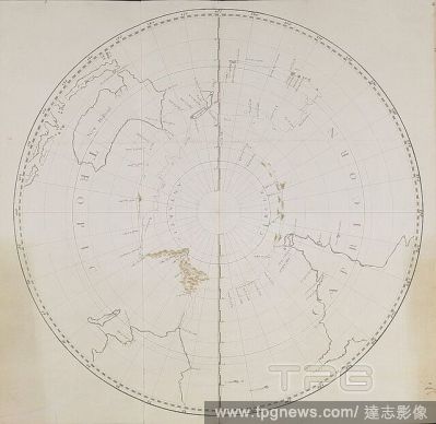
Editorial A chart of the southern hemisphere (1776.) The tracks of the ship, 'Adventure'. TWENTY-TWO Charts, views of Headlands, etc., taken during Captain Cook's voyage in the Resolution through the Pacific and Southern Ocean, 1772-1774. Large Folio. [15,500.]....
- 2022-01-18
- 1
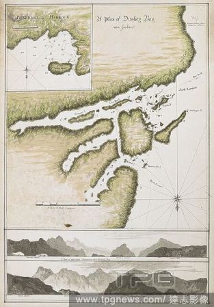
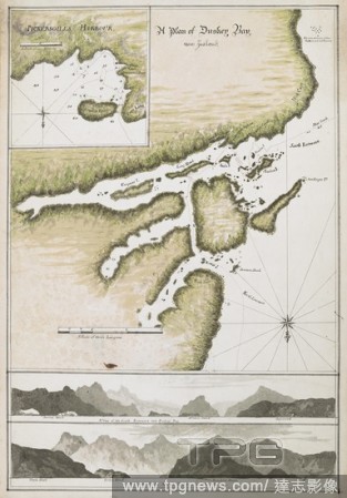
Editorial A Plan of Dusky Bay, New Zealand, 26 March-3 May 1773 Shows ship’s track. Detail of Pickersgills Harbour with Ships Cove, Astronomers Point and Crayfish Island.Panoramas of A View of the South Entrance into Duskey Bay and A View of the North Entranc...
- 2022-01-18
- 1
Editorial Illsutration of harbour on the Indian coastline. . Observations upon several Voyages to India Out and Home. London, 1720. Observations upon several Voyages to India Out and Home; as also Remarks on the ports and places touched at in that Voyage ... Ill...
- 2022-01-18
- 1
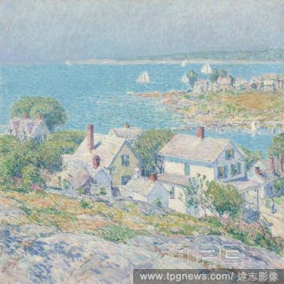
Editorial New England Headlands. Childe Hassam; American, 1859-1935. Date: 1899. Dimensions: 68.9 ? 68.9 cm (27 1/8 ? 27 1/8 in.). Oil on canvas. Origin: Gloucester.
- 2022-01-18
- 1

Editorial Venus transits the sun, San Francisco, California, United States - 06 Jun 2012
- 2021-08-26
- 1
Editorial Golden Gate Bridge turns 75, Golden Gate National Recreation Area, California, United States - 26 May 2012
- 2021-08-25
- 1

Editorial Warm weather continues to bring morning fog to San Francisco, California - 27 Sep 2009
- 2021-08-21
- 1

Editorial Cornish Headlands. Date/Period: 1898. Painting. Oil on canvas Oil on canvas. Height: 765.30 mm (30.12 in); Width: 1,019.30 mm (40.12 in).
- 2021-06-04
- 1

Editorial Headlands, Lake, Ohio, United States, Bombus (Separatobombus) griseocollis (De Geer), Animalia, Arthropoda, Insecta, Hymenoptera, Apidae, Apinae.
- 2021-02-22
- 1

Editorial Headlands, Lake, Ohio, United States, Bombus (Separatobombus) griseocollis (De Geer), Animalia, Arthropoda, Insecta, Hymenoptera, Apidae, Apinae.
- 2021-02-22
- 1

Editorial Headlands, Lake, Ohio, United States, Bombus (Fervidobombus) pensylvanicus pensylvanicus (De Geer), Animalia, Arthropoda, Insecta, Hymenoptera, Apidae, Apinae.
- 2021-02-22
- 1

Editorial Headlands, Lake, Ohio, United States, Bombus (Separatobombus) griseocollis (De Geer), Animalia, Arthropoda, Insecta, Hymenoptera, Apidae, Apinae.
- 2021-02-22
- 1
Editorial Illsutration of harbour on the Indian coastline. . Observations upon several Voyages to India Out and Home. London, 1720. Observations upon several Voyages to India Out and Home; as also Remarks on the ports and places touched at in that Voyage ... Ill...
- 2020-09-28
- 1

Editorial Golden Gate Bridge
- 2020-06-09
- 1

Editorial California Businesses
- 2020-03-13
- 1
Editorial New England Headlands. Childe Hassam; American, 1859-1935. Date: 1899. Dimensions: 68.9 ? 68.9 cm (27 1/8 ? 27 1/8 in.). Oil on canvas. Origin: Gloucester.
- 2019-12-17
- 1

Editorial New England Headlands. Childe Hassam; American, 1859-1935. Date: 1899. Dimensions: 68.9 ? 68.9 cm (27 1/8 ? 27 1/8 in.). Oil on canvas. Origin: Gloucester.
- 2019-11-19
- 1

Editorial Cornish Headlands. Date/Period: 1898. Painting. Oil on canvas Oil on canvas. Height: 765.30 mm (30.12 in); Width: 1,019.30 mm (40.12 in).
- 2019-06-06
- 1

Editorial New England Headlands. Childe Hassam; American, 1859-1935. Date: 1899. Dimensions: 68.9 ? 68.9 cm (27 1/8 ? 27 1/8 in.). Oil on canvas. Origin: Gloucester.
- 2019-03-18
- 1
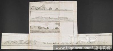
Editorial Various views of headlands on the coasts of New Zealand; drawn by Lieut. James Cook, in his first voyage. Charts, Plans, Views, and Drawings taken on board the Endeavour during Captain Cook's First Voyage, 1768-1771. ca. 1769-1770. Source: Add. 7085, N...
- 2018-12-06
- 1

Editorial [Whole map] Map of the southern hemisphere showing the route of the Resolution during Captain Cook's Second Voyage, from Capetown in November 1772, to Caledonia in October 1774. Three coastal views; Resolution Harbour, Frieslands Head and the Sandwich ...
- 2018-12-06
- 1
Editorial Various views of headlands on the coasts of New Zealand; drawn by Lieut. James Cook, in his first voyage. Charts, Plans, Views, and Drawings taken on board the Endeavour during Captain Cook's First Voyage, 1768-1771. ca. 1769-1770. Source: Add. 7085, N...
- 2018-12-06
- 1

Editorial Chart and picture of Savage island. Niue was first seen by Captain James Cook in 1774. He named the island "Savage Island". TWENTY-TWO Charts, views of Headlands, etc., taken during Captain Cook's voyage in the Resolution through the Pacific and South...
- 2018-12-06
- 1

Editorial Map of New Caledonia, with two coastal views; Ballarde Harbour, and the Isle of Pines. October 1774. Charts, and views of headlands, taken during Captain Cook's Second Voyage, 1772-1774. Source: Add. 15500, No.14. Language: English.
- 2018-12-06
- 1
Editorial A chart of the southern hemisphere (1776.) The tracks of the ship, 'Adventure'. TWENTY-TWO Charts, views of Headlands, etc., taken during Captain Cook's voyage in the Resolution through the Pacific and Southern Ocean, 1772-1774. Large Folio. [15,500.]....
- 2018-12-06
- 1
Editorial A Plan of Dusky Bay, New Zealand, 26 March-3 May 1773 Shows ship’s track. Detail of Pickersgills Harbour with Ships Cove, Astronomers Point and Crayfish Island.Panoramas of A View of the South Entrance into Duskey Bay and A View of the North Entranc...
- 2018-12-06
- 1
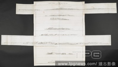
Editorial Various views of headlands on the coasts of New Zealand; drawn by Lieut. James Cook, in his first voyage. Charts, Plans, Views, and Drawings taken on board the Endeavour during Captain Cook's First Voyage, 1768-1771. ca. 1769-1770. Source: Add. 7085, N...
- 2018-12-06
- 1
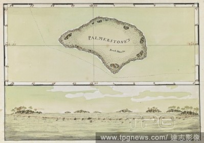
Editorial (Whole Map) Chart of Palmerston Island, with coastal view. Captain Cook reached this small island, near Niue, on 16th June 1774. Charts, and views of headlands, taken during Captain Cook's Second Voyage, 1772-1774. Source: Add. 15500, No.10. Language: ...
- 2018-12-06
- 1
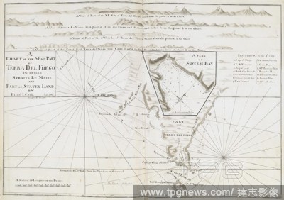
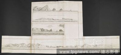
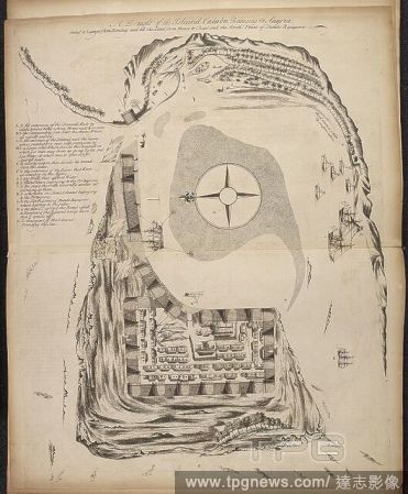
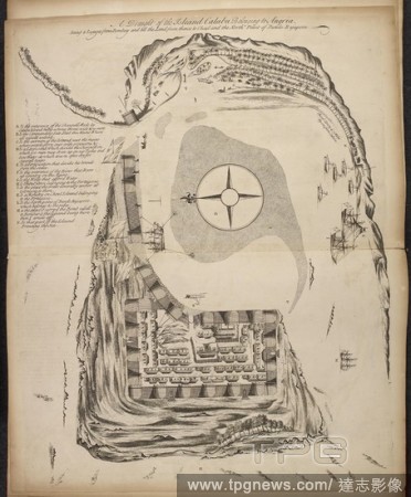
Editorial A chart of the S.-E. part of Terra del Fuego, including Straits Le Maire and part of Staten Land, on a scale of 4 leagues to an inch; with a chart of Success Bay, on a scale of 2 inches to a mile; and four views of headlands in Terra del Fuego; drawn b...
- 2018-12-06
- 1
Editorial Illsutration of harbour on the Indian coastline. . Observations upon several Voyages to India Out and Home. London, 1720. Observations upon several Voyages to India Out and Home; as also Remarks on the ports and places touched at in that Voyage ... Ill...
- 2018-12-06
- 1

Editorial HEADLANDS NORTH OF THE COLORADO RIVER PLATEAU. Date/Period: 1872.
- 2018-10-11
- 6
Editorial Cornish Headlands. Date/Period: 1898. Painting. Oil on canvas Oil on canvas. Height: 765.30 mm (30.12 in); Width: 1,019.30 mm (40.12 in).
- 2018-10-11
- 1
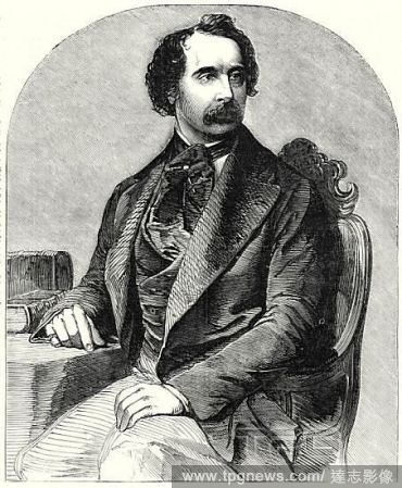
Editorial Charles Dickens, from a recent daguerreotype by Mayall, 1 December, 1855. . Memoir of Charles Dickens. . The lives of men of genius when happy, are ordinarily uneventful. It may, perhaps, be one of the reaspms for the paucity of materials available for...
- 2018-07-23
- 1
 Loading