
filter
-
Brand
- By Category
- Direction
- Date Range
170Events
Pictures
Events

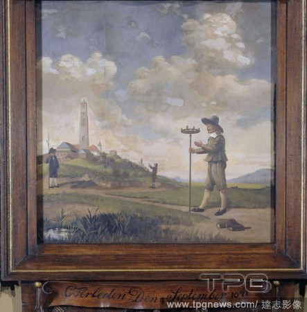
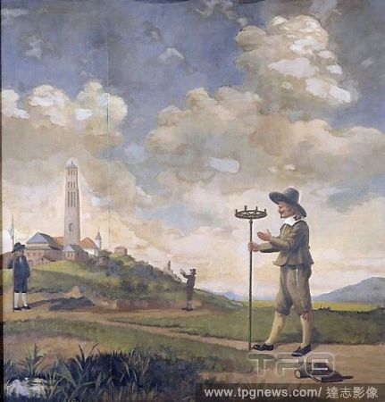
Editorial Portrait of a Surveyor (Andries van der Wal). Dating: 1650 - 1674. Place: Northern Netherlands. Measurements: h 88 cm ? w 87 cm.
- 2020-03-02
- 1
Editorial Portrait of a Surveyor (Andries van der Wal). Dating: 1650 - 1674. Place: Northern Netherlands. Measurements: h 88 cm ? w 87 cm.
- 2020-01-15
- 1
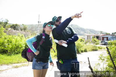
Editorial Surveyor Randolph Ortega and his wife Caissa Vega inspect the collapsed Agripina Seda School in Guánica, P.R., Jan. 11, 2020. (Erika P. Rodriguez/The New York Times)
- 2020-01-12
- 1
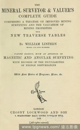
Editorial The mineral surveyor & valuer's complete guide : comprising a treatise on improved mining surveying and the valuation of mining properties with new traverse tables : Lintern, William.
- 2019-12-18
- 1

Editorial Surveyor chain of 20 meters, Measuring chain with spring ring to be divided into two parts of 10 meters. 50 centimeters per link (from ring to ring). Provided with an oval ring with a keep in groups of two links. At the beginning a round brass handle, ...
- 2019-12-18
- 1
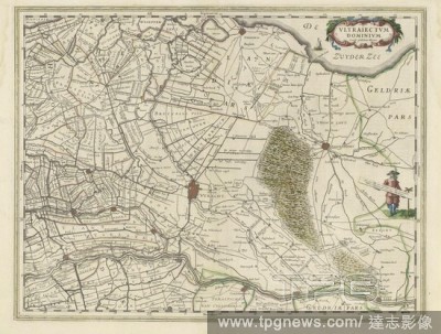
Editorial Map of the province of Utrecht, Vltraiectvm Dominivm (title on object), Map of the province of Utrecht on a scale of 1: 150 000 with the north on the right. Top right a cartouche with the title. Right: a standing surveyor with a distance bar in his han...
- 2019-12-18
- 1
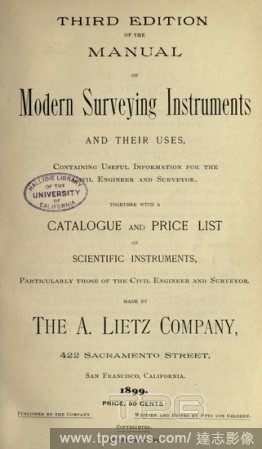
Editorial Manual of modern surveying instruments and their uses, containing useful information for the civil engineer and surveyor, together with a catalogue & price list of scientific instruments... made by the A. Lietz Company .. : Lietz, (A.), company.
- 2019-12-18
- 1

Editorial Design for a Freestanding Tomb Seen in Elevation and Plan.
- 2019-11-18
- 1

Editorial Marine science surveyor
- 2019-07-30
- 1

Editorial Panorama View of Apollo 12 Lunar Surface Photos
- 2019-07-19
- 1
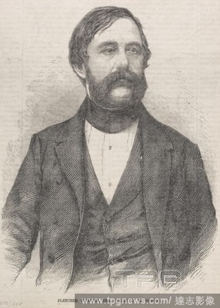
Editorial Fletcher Webster, Esq., Surveyor of Boston, 1859. Winslow Homer (American, 1836-1910). Wood engraving.
- 2019-04-01
- 1

Editorial Design for a Freestanding Tomb Seen in Elevation and Plan.
- 2019-02-15
- 1
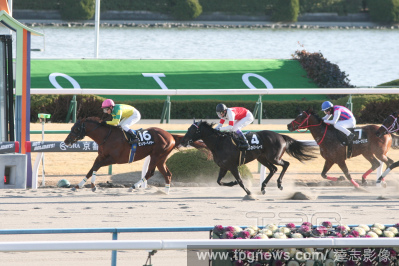
Editorial Horse racing in Kyoto
- 2019-01-29
- 1

Editorial Portrait of a Surveyor (Andries van der Wal). Dating: 1650 - 1674. Place: Northern Netherlands. Measurements: h 88 cm ? w 87 cm.
- 2019-01-25
- 1
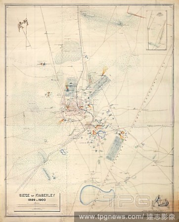
Editorial Siege of Kimberley. South Africa; 1900. [Whole map] Plan of the Siege of Kimberley, 14 October 1899 - 15 February 1900; with pictorial compass points showing speared Boers. Surveyed by Colonel A.J. O'Meara, R.E., and signed by Claude O. Lucas, Cape Gov...
- 2019-01-24
- 1
Editorial Sir George Everest. 1834. Sir George Everest, Surveyor General of India (1790-1866), and an assistant supervising work on the Great Trigonometrical Survey Pencil and wash. Originally published/produced in 1834 . Source: WD 3114,.
- 2019-01-23
- 1
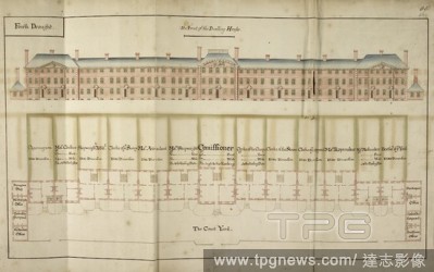
Editorial Front elevation of building at Plymouth Docks in 1694. Naval dockyards of the Royal Navy fleet. . An Account of the generall progress and advancement of His Ma- jesties new docks and yard at Plymouth. A Volume formerly belonging to Robert Harley Esq. a...
- 2019-01-23
- 1
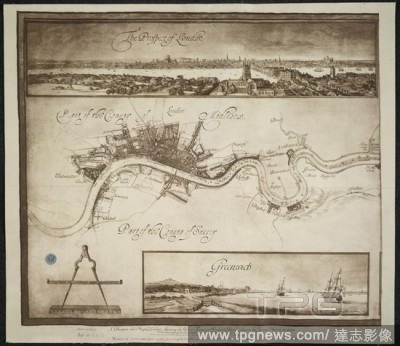
Editorial A Prospect of London. A Mapp or Description of the River of Thames from. A prospect and map of London, showing the River Thames to Woolwich Reach. Image taken from: A Mapp or Description of the River of Thames from Westminster to the Sea ... made by Jo...
- 2019-01-23
- 1
Editorial A plan of part of the coast of East Florida. A PLAN of Part of the Coast of EAST FLORIDA including S.t John's River from an actual Survey BY W.m Gerard De Brahm Esq.r SURVEYOR GENERAL of the Southern District of NORTH AMERICA. [London] : 1769, done by ...
- 2018-12-06
- 1

Editorial Siege of Kimberley. South Africa; 1900. [Whole map] Plan of the Siege of Kimberley, 14 October 1899 - 15 February 1900; with pictorial compass points showing speared Boers. Surveyed by Colonel A.J. O'Meara, R.E., and signed by Claude O. Lucas, Cape Gov...
- 2018-12-06
- 1
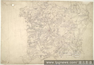
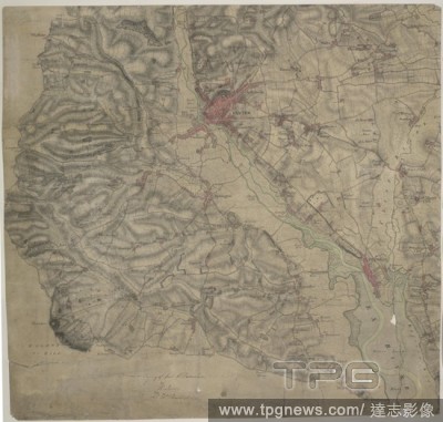
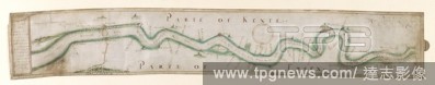
Editorial Faversham, Kent. 18th century map. This is a plan of the Kentish flatlands surrounding Faversham, to the south of The Swale. Ruled red-ink lines radiating from observation stations and intersecting across the map, indicate angular measurements taken by...
- 2018-12-06
- 2

Editorial 'View of Darjeeling in 1852'. Drawn from nature by Captain Walter S. Sherwill, Bengal Army Revenue Surveyor. Lithograph by Maclure, Macdonald and Macgregor. 'View of Darjeeling in 1852'. London, c.1855. Source: P389.
- 2018-12-06
- 1
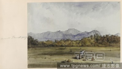
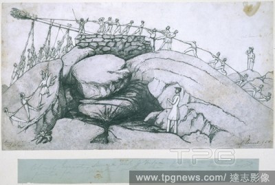
Editorial View of Mount Ilamickipang, with a surveyor [Goodall], in the foreground. Made during Sir Robert Schomburgk's expedition into the interior of British Guiana. Drawings and sketches illustrating the scenery of the interior of British Guiana. British Guia...
- 2018-12-06
- 1
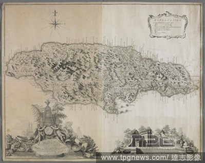
Editorial A map of Jamaica. To the Right Honorable GEORGE, Earl of HALIFAX, One of His Majesty's Principal Secretary's of STATE, &c,&c, This MAP of the Island of JAMAICA. : (laid down from the Papers, and under the direction of HENRY MOORE Esqr. His Majesty's Li...
- 2018-12-06
- 1
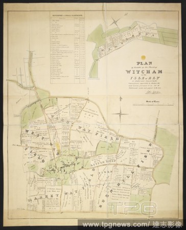
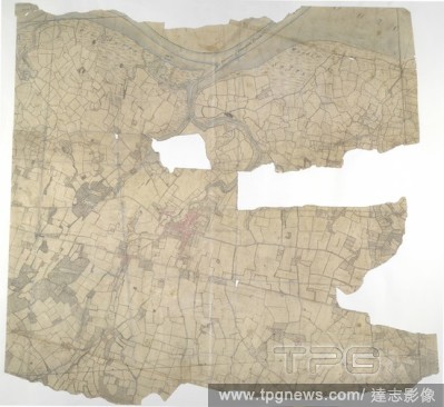
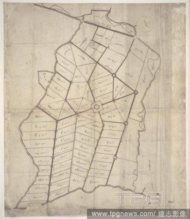
Editorial A plan of Lands in the Parish of Witcham in the Isle of Ely. Plan of Lands in the Parish of Witcham in the Isle of Ely, as allotted and awarded by the Commissioner appointed to inclose the said Lands ... 1838 Alexander Watford, Surveyor. Scale of chain...
- 2018-12-06
- 1
Editorial Stow Market. This is a plan of the Gipping Valley in Suffolk. The circular hole in the top left-hand margin indicates that an 'Ordnance Office Copy' blind stamp has been removed from the manuscript. The die has cut through the paper causing the stamp t...
- 2018-12-06
- 1
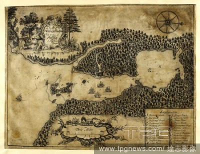
Editorial Plan of Chebuctoo (Chebucto) harbour; with the town of Hallefax (Halifax). . "A plan of Chebuctoo harbour; with the town of Hallefax, by Moses Harris, surveyor, 1749;" drawn on vellum, on a scale of 1 1/12 inch to a mile. 1749. Ms. 1 f. 4 1/2 in. x 12 ...
- 2018-12-06
- 1
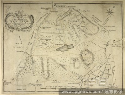
Editorial A plan of His Majesty's New Park, at Richmond, Surrey. A Plan of his Majesty's New Park, at Richmond in Surrey. Taken Sep: 1754. By Edwd John Eyre, Surveyor. A Scale of 80 Chains or One Mile[ = 147 mm]. [London], [1754]. Source: Maps K.Top.41.15.b.2. L...
- 2018-12-06
- 1
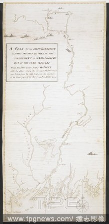
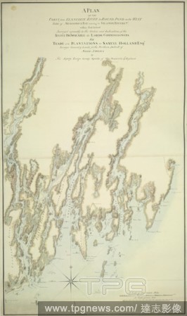
Editorial A plan of the River Kennebeck as it was surveyed by order of the Government of Massachusets Bay in the year MDCCLXI from the falls above Halifax unto the place where the surveyor John Small was killed, from his field book, with the addition of lower pa...
- 2018-12-06
- 1

Editorial Bala Hissar. Plan and Survey of the Bala Hissar or Fort of Cabu. Calcutta : Surveyor General's Office, 1878. Plan and Survey of the Bala Hissar or Fort of Cabul. Image taken from Plan and Survey of the Bala Hissar or Fort of Cabul, shewing the present...
- 2018-12-06
- 1
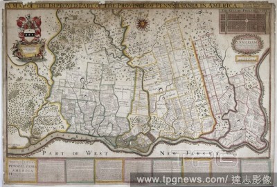
Editorial A map of Pennsylvania, 1687. . "A map of the province of Pennsilvania, containing the three countyes of Chester, Philadelphia, and Bucks, as far as yet surveyed and laid out, &c., with the names of the owners, by Thomas Holme, surveyor-general," 1...
- 2018-12-06
- 1
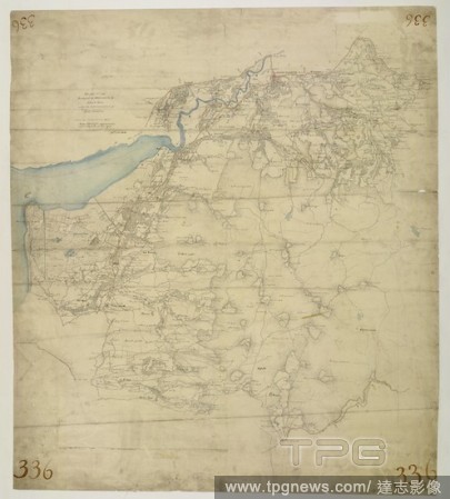
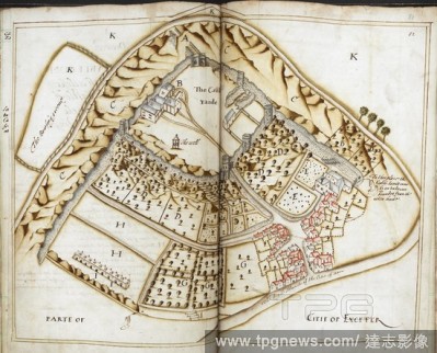
Editorial Exeter. This drawing covers the land either side of the Ex River. Exeter, the largest settlement, is shown in great detail. A barracks, poor house and 'New Gaol' are shown by red blocks on the outskirts of the settlement. The main road leading into Exe...
- 2018-12-06
- 1
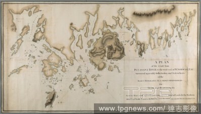
Editorial A plan of the coast from Pleasant River to the west end of Penobscott Bay. A PLAN of the Coast from PLEASANT RIVER to the west end of PENOBSCOT BAY / Surveyed agreeably to the Orders and Instructions of the RIGHT HONORABLE the LORDS COMMISSIONERS for T...
- 2018-12-06
- 1
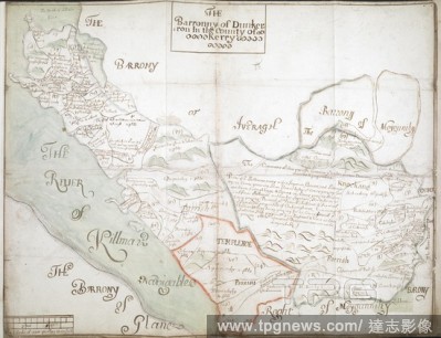
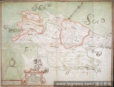
Editorial The Barronny of Dunkerron', co. Kerry (Munster), by an unidentified surveyor; [1655-1656?]. No compass points, but west approx. at top. Scale bar: 320 perches to the inch [1:63360]. Showing, rather crudely, boundaries of parishes and townlands, with pl...
- 2018-12-06
- 1
Editorial A Plan of Part of the Marches of Calais. This plan shows a projected settlement near Calais, divided into allotments, with the admeasurements on each, and with roads and forts marked out. It was drawn in 1541 by the surveyor Richard Lee. 1541. Ink on v...
- 2018-12-06
- 1
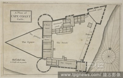
Editorial A plan of cape coast castle. Cape Coast Castle is one of about forty "slave castles", or large commercial forts, built on the Gold Coast of West Africa by European traders. Thirty different Drafts of Guinea by William Smith, Surveyor to ye Royal Afric...
- 2018-12-06
- 1
Editorial Elizabeth I's route to Tilbury. Pictorial Chart of the Thames Estuary. London; 1588. [Whole chart] Chart of the Thames from Lambeth to Tilbury, by the Surveyor of Works, to show the route followed, or intended to be followed, by Queen Elizabeth I on th...
- 2018-12-06
- 1
Editorial This drawing covers the boundary between the counties of Cardiganshire and Montgomeryshire. The border is marked as a red pecked line, following the course of the River Dovey for much of its length. Archaeological sites are noted in gothic script, an o...
- 2018-12-06
- 1
Editorial Plan of Exeter Castle, and part of the city of Exeter, surveyed by John Norden the elder, and John Norden the younger, deputies to Sir James Fullerton, Surveyor-General of the Lands and Land revenues of Prince Charles. June-September 1617. Survey of Pr...
- 2018-12-06
- 1
Editorial Halstow (Kent). Drawing showing the area around Halstow in Kent. This map is drawn on rectangular sheet lines, enclosed by a black border. Fields are coloured brown where cultivated, and green or blank if untilled. Marshland dominates this estuarine la...
- 2018-12-06
- 1
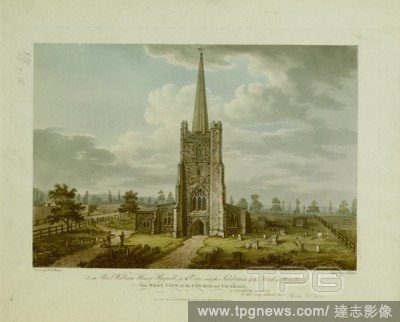
Editorial Figures by the entrance to St. Andrew's Hornchurch; gravestones in front; trees in the distance; the vicarage on the left. To the Revd William Henry Reynell A.M. Vicar and the Inhabitants of the Parish of Hornchurch This WEST VIEW of the CHURCH and VIC...
- 2018-12-06
- 1
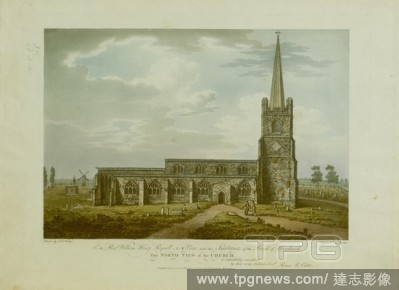
Editorial Figures standing on a path in the churchyard of St. Andrew's Hornchurch; gravestones in front; a windmill to the left in the distance . To the Revd William Henry Reynell A.M. Vicar and the Inhabitants of the Parish of Hornchurch This NORTH VIEW OF THE ...
- 2018-12-06
- 1
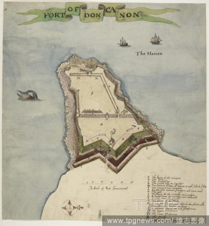
Editorial Duncannon Fort, County Wexford, Leinster, Ireland. This map shows Duncannon fort in County Wexford. It dates from around 1611 and is therefore contemporary with the English plantation scheme. This scheme aimed to establish an English colony in Ulster ...
- 2018-12-06
- 1
Editorial A map to illustrate a report upon the Bhaugiruthee River. Map to illustrate a report upon the Bhaugiruthee River, by Capt? W. S. Sherwill ... Scale, 16 miles to an inch. Calcutta : Surveyor General's Office, 1857. Source: Maps 53580.(27.). Language: ...
- 2018-12-06
- 1
Editorial An accurate survey and measurement of Plymouth and Dock towns, with their fortifications, and the adjacent country. An accurate survey and measurement of Plymouth and Dock towns, with their fortifications, and the adjacent country; surveyed by order of...
- 2018-12-06
- 1
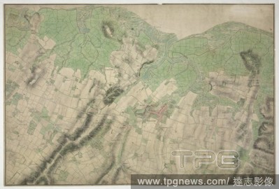
Editorial Stourbridge. This plan covers parts of Worcestershire and Warwickshire. Hills and reliefs are illustrated by a combination of brushwork interlining ('hachures'), layering of colour washes and the use of aerial perspective. Tollroads are highlighted in ...
- 2018-12-06
- 1
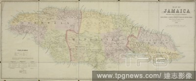
Editorial A map of Jamaica. Map of Jamaica prepared ... under the direction of Major General J.R. Mann, R.E. ... By T. Harrison, Government Surveyor. Scale, 1 : 171,000. 1881. Source: Maps 81710.(3.). Language: English.
- 2018-12-06
- 1
Editorial A plan of the coast from Kennebeck River to Round Pond. A PLAN OF THE COAST from KENNEBECK RIVER to ROUND POND on the WEST SIDE of MUSCONGUS BAY, including the ISLANDS, RIVERS, &c. within that Extent / Surveyed agreeably to the Orders and Instructions ...
- 2018-12-06
- 1
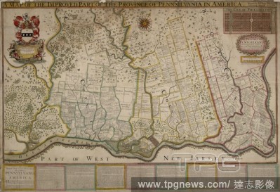
Editorial A map of the province of Pennsylvania, containing the three counties of Chester, Philadelphia, and Bucks. "A map of the province of Pennsilvania, containing the three countyes of Chester, Philadelphia, and Bucks, as far as yet surveyed and laid out, &c...
- 2018-12-06
- 1
Editorial The barony of Carbury, co. Cork (Munster), by an unidentified surveyor; [1655-1656?]. No scale indicated. North north west at top. Showing boundaries (in colour) and names of parishes, and townland boundaries. Sea coast, rivers and areas of bog are ind...
- 2018-12-06
- 1
Editorial The Barronny of Iveragh', co. Kerry (Munster), by an unidentified surveyor; [1655-1656?]. North west at top. Scale: 320 perches to the inch [1:63360]. Showing boundaries of parishes (in colour) and townlands, with place-names. Rivers and areas of bog a...
- 2018-12-06
- 2

Editorial A chart of the peninsula of Nova Scotia. A CHART OF THE PENINSULA OF NOVA SCOTIA / done by order of His Excellency CHS. LAWRENCE Esqr. Lieut. Govr. & Commr. in Chief of his Majesty's Province of NOVA SCOTIA from many actual Surveys; and the whole corre...
- 2018-12-06
- 1
Editorial Merston, Kent. 18th century map. This map is drawn on rectangular sheet lines, enclosed by a black border. Fields are coloured brown where cultivated, and green or blank if untilled. Stonework buildings or structures are drawn in red ink at the major s...
- 2018-12-06
- 1
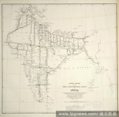
Editorial An index chart. Index Chart to the Great Trigonometrical Survey of. Calcutta : Surveyor General's Office, 1870[-1895]. Index Chart to the Great Trigonometrical Survey of India. Sh. 595 x 570 mm. Image taken from Index Chart to the Great Trigonometrica...
- 2018-12-06
- 1

Editorial A map of Birmingham. To the Right Honourable William Earl of Dartmouth ... this Map of Birmingham engraved from a ... survey made in the years 1824 & 1825, is ... dedicated by ... Beilby, Knott & Beilby. J. Pigott Smith, Surveyor & Engineer. Birmingham...
- 2018-12-06
- 1
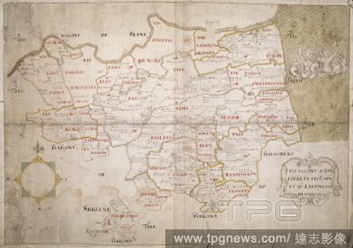
Editorial The Barony of Duleeke in the County of East Meath [Leinster] Described', by an unidentified surveyor; [1655-1656?]. No scale given. North at top. Showing boundaries of parishes (in colour) and townlands, with place-names. Rivers, areas of bog and the s...
- 2018-12-06
- 1
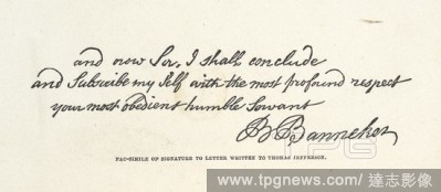
Editorial The signature of Benjamin Banneker, a free African American astronomer, mathematician, surveyor, almanac author and farmer. . Banneker the Afric-American Astronomer. From the posthumous papers of M. E. Tyson. Friends' Book Association: Philadelphia, 18...
- 2018-12-06
- 1

Editorial Front elevation of building at Plymouth Docks in 1694. Naval dockyards of the Royal Navy fleet. . An Account of the generall progress and advancement of His Ma- jesties new docks and yard at Plymouth. A Volume formerly belonging to Robert Harley Esq. a...
- 2018-12-06
- 1

Editorial A Prospect of London. A Mapp or Description of the River of Thames from. A prospect and map of London, showing the River Thames to Woolwich Reach. Image taken from: A Mapp or Description of the River of Thames from Westminster to the Sea ... made by Jo...
- 2018-12-06
- 1

Editorial General plan of the part of the city of London which was destroyed by the Great Fire of 1666. . General plan of that part of the City of London, which was destroyed by the Great Fire of 1666 : shewing also the present state thereof constructed from aut...
- 2018-12-06
- 1

Editorial Design for a Freestanding Tomb Seen in Elevation and Plan.
- 2018-08-06
- 1

Editorial Abraham van der Doort (1575/1580-1640). Dutch artist, Surveyor of the Pictures of King Charles I. Portrait by William Dobson (1611-1646), late 1630s. The State Hermitage Museum. Saint Petersburg. Russia.
- 2018-07-30
- 1
Editorial Portrait of a Surveyor, Andries van der Wal, Anonymous, 1650 - 1674.
- 2018-07-30
- 1
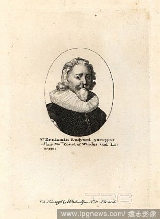
Editorial Sir Benjamin Rudgerd, surveyor.
- 2018-07-25
- 1

Editorial TESTIMONIAL TO MAJOR-GENERAL SIR ANDREW SCOTT WAUGH, LATE SURVEYOR-GENERAL OF INDIA, 1862.
- 2018-07-24
- 1
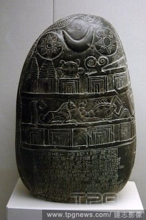
Editorial Mesopotamian Art. Kassite Dynasty. The Eanna-shum-iddina kudurru (1125-1100 B.C.). It describes the land grant made by Governor Eanna-shum-iddina to Gula-Eresh witnessed by his surveyor Amurru-Bel-Zeri. The bottom is inscribed in cuneiform script and ...
- 2018-07-24
- 1
 Loading