
filter
-
Brand
- By Category
- Direction
- Date Range
675Events
Pictures
Events

Editorial A Thick Night Off the Goodwins, from the "Illustrated London News".
- 2019-02-22
- 1

Editorial Incense burner (koro).
- 2019-02-22
- 1

Editorial Pocket Qur'an.
- 2019-02-22
- 1

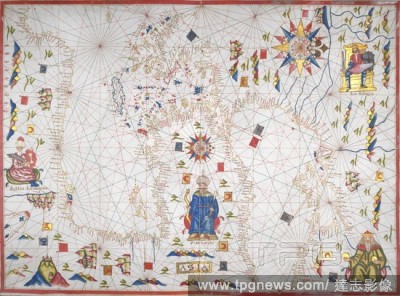
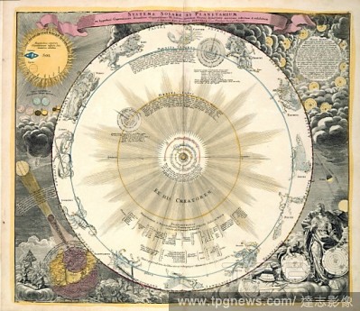
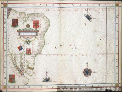
Editorial Chart of the Signs of the Zodiac with Venus, Cupid, and a Bishop Saint.
- 2019-02-22
- 1

Editorial TEAPOT.
- 2019-02-15
- 1

Editorial Vase (one of a pair).
- 2019-02-15
- 1

Editorial Vase (one of a pair).
- 2019-02-15
- 1

Editorial Sampler listing the counties of England.
- 2019-02-15
- 1

Editorial CUP.
- 2019-02-15
- 1
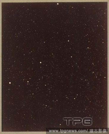
Editorial A Section of the Constellation Cygnus (August 13, 1885).
- 2019-02-11
- 1

Editorial BOWL.
- 2019-02-11
- 1

Editorial Beaker and saucer.
- 2019-02-11
- 1

Editorial Color Chart with Annotations [verso]. Dated: 1884-1888. Dimensions: overall: 16.9 x 13.2 cm (6 5/8 x 5 3/16 in.). Medium: pen and brown ink on wove paper.
- 2019-02-01
- 1
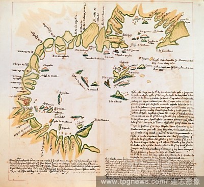
Editorial The Bay of Panama. Charts of Pacific Coasts of America. England [London]; circa 1685. [Whole chart] Chart of the Bay of Panama, between Point Guarachine and the island of Gallera Image taken from Charts of Pacific Coasts of America. Originally publis...
- 2019-01-24
- 1
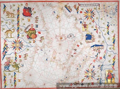
Editorial Western Mediterranean Sea. Portolano. Spain; before 1600. [Whole chart] Chart of the western Mediterranean Sea, from the south coast of Spain, and North Africa, to the west coast of Greece. The chart includes the western part of the Baltic Sea Image t...
- 2019-01-24
- 1
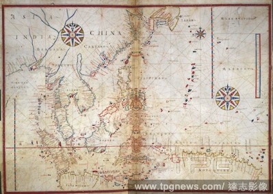
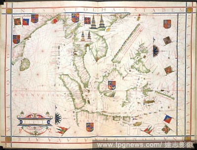
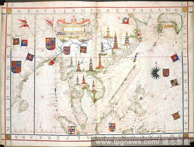
Editorial Chart of South East Asia. Portolano. France [Marseilles]; 1613. [Whole chart] Chart of the coasts of Bengal, Siam, Sumatra, Java, China, and the islands of the South China Seas and North Pacific Ocean Image taken from Portolano. Originally published/...
- 2019-01-24
- 1
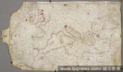
Editorial Western coast of Europe. Portolano. Spain; before 1600. (Whole chart) Chart of the western coast of Europe, from the British Isles, France, Spain, Portugal, and part of the Mediterranean Sea with northern coast of Africa including Madeira. Decorated wi...
- 2019-01-24
- 2
Editorial The North sea. A chart. A Chart of the Northerne Sea ... [London] : [J. Seller], [1671]. Source: Maps.C.22.d.2, no.2.
- 2019-01-24
- 1
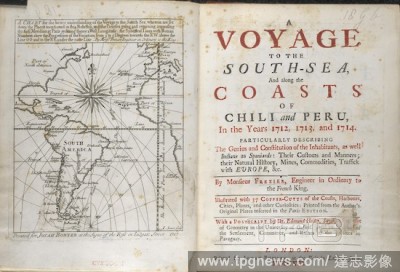
Editorial A voyage to the South Sea. A chart for the better understanding of the voyage to the South Sea... A voyage to the South-Sea and along the coasts of Chili and Peru in 1712, 1713 and 1714. [Translated from the French.] With 37 copper-cutts. A postscript ...
- 2019-01-24
- 1
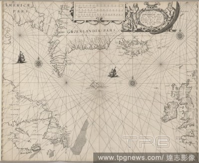
Editorial Faeroe Islands. [The Light of Navigation, wherein are declared and. Amsterdam : Jean Jeansson, 1620. Chart of the Faeroes or Faroe Islands. Image taken from [The Light of Navigation, wherein are declared and lively pourtrayed, all the Coasts and Haven...
- 2019-01-24
- 1

Editorial Coast about Bombay. c 1680. A chart of the coast about Bombay; drawn about 1680, by William Hacke, on a scale of 6 1/2 English miles to an inch. Ms. 2 f. 2 in. x 1 f. 6 in.. Originally published/produced in c 1680. . Source: Maps.9.Tab.37.(30),.
- 2019-01-24
- 1
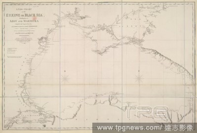
Editorial Black Sea. A new Chart of the Euxine or Black Sea, including. 1806. A new Chart of the Euxine or Black Sea. Image taken from A new Chart of the Euxine or Black Sea, including those of Azov and Marmora. Originally published/produced in 1806. . Source:...
- 2019-01-24
- 1
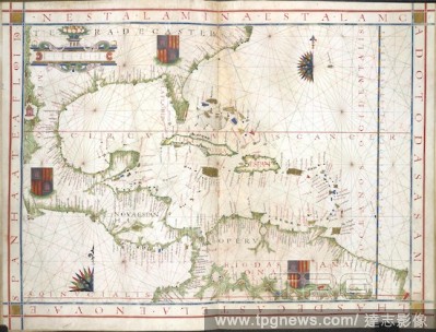
Editorial Gulf of Mexico and West Indies. Universalis Orbis Hydrographia. Portugal; 1573. (Whole chart) Chart of the Gulf of Mexico; from Florida, the east coast of Mexico and Central America, and the north coast of South America; with Cuba, Haiti, and the West ...
- 2019-01-24
- 1

Editorial Central America and West Indies. Portolano. Spain; before 1600. [Whole chart] Chart of the coast of the southern coast of North America, Central America and the West Indies, and the northern coast of South America Image taken from Portolano. Original...
- 2019-01-24
- 1

Editorial A colored "chart of Turon Bay and of the island of Callao, or Campbello, surveyed in June, 1792;" drawn by H.W. Parish, on a scale of 2 nautical miles to an inch. Engraved in Staunton's Embassy, Atlas, No. 3. . A colored "chart of Turon Bay and of the...
- 2019-01-24
- 1
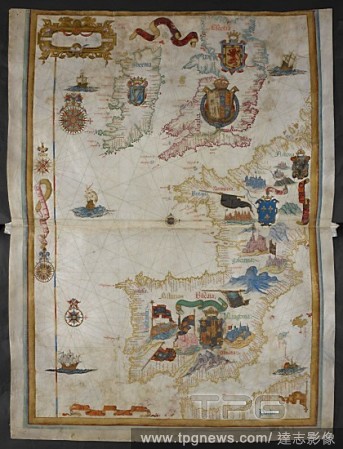
Editorial Chart of western Europe, including the British Isles, Ireland, France, Spain, Portugal, the western Mediterranean Sea, and part of North Africa. With armorial decoration. Queen Mary Atlas. 1558. Source: Add. 5415 A, ff.9v-10.
- 2019-01-24
- 1
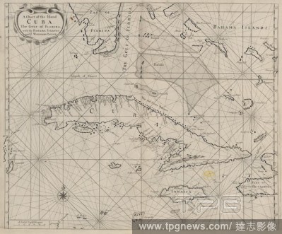
Editorial A chart of Cuba. A Chart of the Island Cuba ... [London], [1704?]. Source: Maps.C.27.d.10, no.13. Language: English.
- 2019-01-24
- 1

Editorial North Atlantic coast of America. Portolano. Italy [Naples?]; circa 1508. [Whole chart] An outline of the east coasts of North and South America. The volume appears to be a copy of one of the early portolani of Visconti Maggiola, of Genoa, and the earli...
- 2019-01-24
- 1
Editorial Malaysia and East Indies. Universalis Orbis Hydrographia. Portugal; 1573. (Whole chart) Chart from the Bay of Bengal, the Malay peninsula, to the South China Sea with Sumatra, Borneo and Java Image taken from Universalis Orbis Hydrographia. Originall...
- 2019-01-24
- 1

Editorial Chart of the eastern coast of America from 51? to 6? north, the West Indies and Gulf of Mexico; with Florida and the north coast of Brazil. Jean Rotz, Boke of Idrography (The 'Rotz Atlas'). 1542. Source: Royal 20 E. IX, ff.23v-24. Language: English.
- 2019-01-24
- 2
Editorial Chart of the coasts of Europe, Asia Minor and north Africa; with the Azores, Madeira, Canary Islands, the Mediterranean Sea and Black Sea. Italy [Ancona]; 1470. Source: Add. 31318 A,. Language: Italian.
- 2019-01-24
- 1
Editorial Lappia and Bay of St Nicholas. Lord Burghley's Atlas. London; 1579. [Whole chart] Chart of the coast of 'Lappia and the Bay of St Nicholas' [the North Cape and Beloye More, with part of the island of Novaya Zemlya]. Produced for William Cecil, Lord Bur...
- 2019-01-24
- 2

Editorial A chart of Malacca and Singapore. A large chart. Defenbeing's straights of Malacca a. London, 1734 (1703). Source: Maps.C.22.d.15, between 71 and 73. Language: English.
- 2019-01-24
- 1

Editorial East Coast of North America. Universalis Orbis Hydrographia. Portugal; 1573. [Whole chart] Chart of the east coast of North America, with the Gulf of St Lawence and Newfoundland Image taken from Universalis Orbis Hydrographia. Originally published/pr...
- 2019-01-24
- 1

Editorial Cuaquem and the Persian Gulf. Itinerary from India to Suez, 1541. Portugal; 1542. [Whole map] Representation of the town of Cuaquem, with chart of the Red Sea and Persian Gulf. From a journal of a voyage from Goa to the Red Sea by Estevao de Gama, Port...
- 2019-01-24
- 1
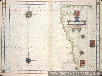
Editorial West coast of South America. Universalis Orbis Hydrographia. Portugal; 1573. (Whole chart) Chart of part of the west coast of South America. Image taken from Universalis Orbis Hydrographia. Originally published/produced in Portugal; 1573. . Source: A...
- 2019-01-24
- 2
Editorial Mediterranean Sea and Black Sea. Portolano. Spain; before 1600. [Whole chart] Chart of the Eastern Mediterranean Sea, from Greece to Turkey, and the Black Sea Image taken from Portolano. Originally published/produced in Spain; before 1600. . Source: ...
- 2019-01-24
- 1
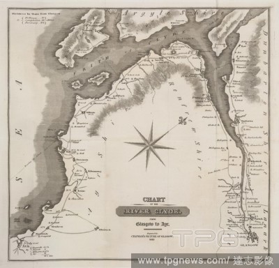
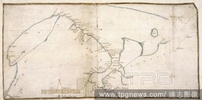
Editorial The River Clyde. The Picture of Glasgow, and Strangers' Guide ... T. R. Chapman: Glasgow, 1818. Chart of the River Clyde from Glasgow to Ayr. Image taken from The Picture of Glasgow, and Strangers' Guide Third edition, enlarged. Embellished with three...
- 2019-01-24
- 1

Editorial Chart of the Indian Ocean. Universalis Orbis Hydrographia. Portugal; 1573. (Whole chart]. Chart of the Arabian Sea; from Ethiopia, the Red Sea, and Arabia, to India and Ceylon Image taken from Universalis Orbis Hydrographia. Originally published/prod...
- 2019-01-24
- 1
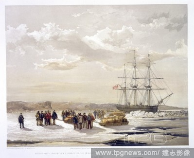
Editorial H.M.S. Investigator. Dedicated ... to Her most gracious Majesty the Que. Day & Son; Ackermann & Co.: London, 1854. Sledge party leaving H.M.S Investigator in Mercy Bay, under command of Lieutenant Gurney Cresswell'. 15 April 1853. Image taken from Ded...
- 2019-01-24
- 1

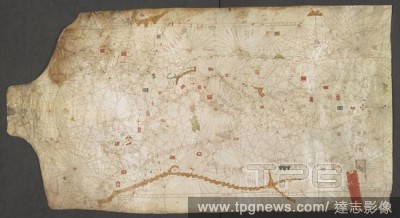
Editorial Chart by Juan de la Cosa (1450-1510). Spain. Madrid. Mavy Museum.
- 2019-01-24
- 1

Editorial Southern coast of South America. Portolano. Spain; before 1600. [Whole chart] Chart of the southern coast of South America. In the centre, the King of Spain wearing armour holds a sword and banner Image taken from Portolano. Originally published/prod...
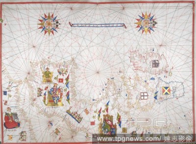
- 2019-01-23
- 1
Editorial Chart of the Eastern Atlantic. Portolano. Italy; 1463. [Whole chart] Chart of the west coasts of Spain, Portugal, and Africa to the Canary Islands, including Madeira and the Azores Image taken from Portolano. Originally published/produced in Italy; 1...
- 2019-01-23
- 1
Editorial Zodiac chart. Atlas Nouus Coelestis in quo mundus spectabilis. e. Nuremberg, 1742. Zodiac chart. Image taken from Atlas Nouus Coelestis in quo mundus spectabilis. et stellarum phoenomena notabilia graphice descripta exhibentur a Ioh. Gabriele Doppelma...
- 2019-01-23
- 1
Editorial South China and East Indies. Universalis Orbis Hydrographia. Portugal; 1573. (Whole chart] Chart from the east coast of India, the Bay of Bengal and the Malay peninsula, to the coast of South China and Japan; with the East Indies including part of Suma...
- 2019-01-23
- 1
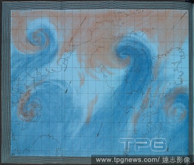
Editorial A 19th century chart showing air currents over the British isles. The illustration show how storms and cyclones develop on the border between warm tropical and cold polar air masses. The Weather Book: a manual of practical meteorology. London, 1863. So...
- 2019-01-23
- 1

Editorial Chart of the North Pacific. Portolano. Italy; 1578. [Whole chart] Chart of the north Pacific Ocean, from the east coast of Mongolia [China] and Japan, to the west coast of North America Image taken from Portolano. Originally published/produced in Ita...
- 2019-01-23
- 1
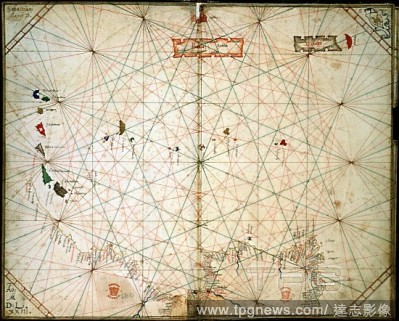
Editorial Chart of the Mediterranean Sea, from the Canary Islands to the Red Sea. A church marks the city of Rome in the centre. Italy; late 14th century. Source: Add. 25691. Language: Latin and Italian.
- 2019-01-23
- 1

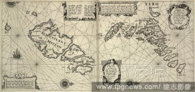
Editorial St.Kilda. [The Light of Navigation, wherein are declared and. Amsterdam : Jean Jeansson, 1620. Chart showing St.Kilda and other islands. Image taken from [The Light of Navigation, wherein are declared and lively pourtrayed, all the Coasts and Havens, ...
- 2019-01-23
- 1
Editorial Chart of Brazil. Universalis Orbis Hydrographia. Portugal; 1573. (Whole chart] Chart of the coast of Brazil, from the River Amazon to the River Plate Image taken from Universalis Orbis Hydrographia. Originally published/produced in Portugal; 1573. . ...
- 2019-01-23
- 1

Editorial 1853, U.S. Coast Survey Nautical Chart or Map of Nantucket, Massachusetts.
- 2019-01-23
- 1
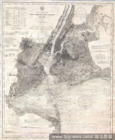
Editorial 1910, U.S. Coast Survey Nautical Chart or Map of New York City and Harbor.
- 2019-01-23
- 1
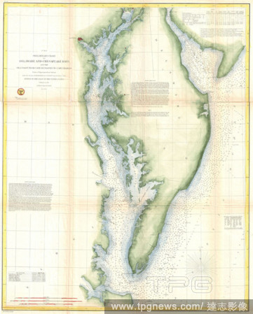
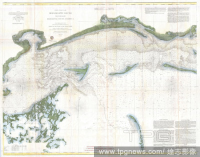
Editorial 1855, U.S. Coast Survey Chart or Map of Chesapeake Bay and Delaware Bay.
- 2019-01-23
- 1
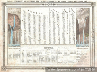
Editorial 1852, Barbie du Bocage Chart of the World's Rivers and Waterfalls.
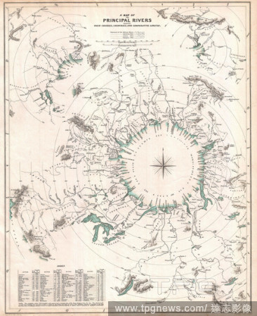
- 2019-01-23
- 1
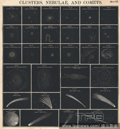
Editorial 1856, Burritt, Huntington Chart of Comets, Star Clusters, Galaxies, and Nebulae.
- 2019-01-23
- 1

Editorial 1868, British Admiralty Chart or Map of the Mediterranean Sea, Italy, Corsica, Greece, Tunisia.
- 2019-01-23
- 1

Editorial 1864, U.S. Coast Survey Map or Chart of St. Georges River and Muscle Ridge Channel, Maine.
- 2019-01-23
- 1

Editorial 1874, U.S. Coast Survey Map or Chart of the Georgia and Carolina Coast, Charleston and Savannah.
- 2019-01-23
- 1

Editorial 1852, Depot de la Marine Nautical Chart or Map of Livorno, Tuscany, Italy.
- 2019-01-23
- 1
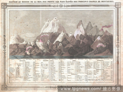
Editorial 1852, Barbie du Bocage Chart of the World's Mountains.
- 2019-01-23
- 1
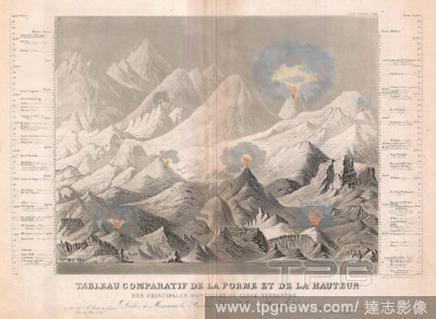
Editorial 1850, Meyer Comparative Chart of World Mountains.
- 2019-01-23
- 1
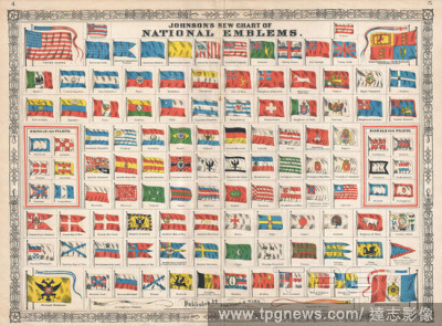
Editorial 1864, Johnson Chart of the Flags and National Emblems of the World.
- 2019-01-23
- 1
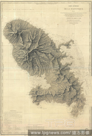
Editorial 1831, Depot de la Marine Nautical Chart or Map of Martinique, West Indies.
- 2019-01-23
- 1

Editorial 1893, U.S. Coast Survey Nautical Chart or Map of the Chesapeake Bay and Delaware Bay.
- 2019-01-23
- 1
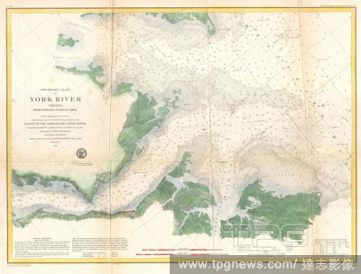
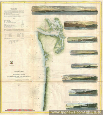
Editorial 1857, U.S. Coast Survey Map or Chart of the Entrance to the York River, Virginia.
- 2019-01-23
- 1

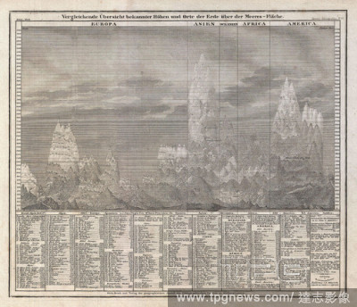
Editorial 1825, Carez Comparative Map or Chart of the World's Great Mountains.
- 2019-01-23
- 2
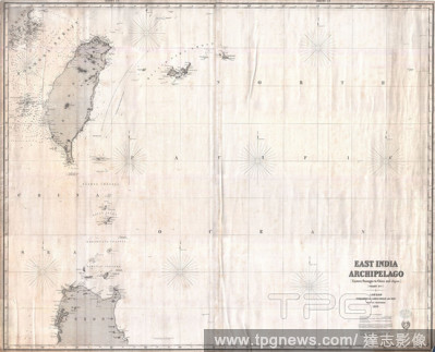
Editorial 1876, Imray Blue-back Nautical Chart or Map of Taiwan, Formosa, China.
- 2019-01-23
- 1

Editorial 1855, U.S. Coast Survey Nautical Chart or Map of the Chesapeake Bay.
- 2019-01-23
- 1

Editorial 1864, Johnson's World Mountains and Rivers Map or Chart.
- 2019-01-23
- 1
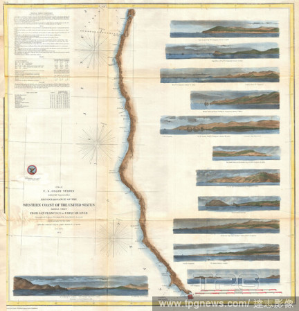
Editorial 1855, U.S. Coast Survey Chart or Map of Washington and Oregon.
- 2019-01-23
- 1
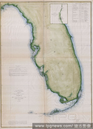
Editorial 1853, U.S.C.S. Map or Chart of Florida.
- 2019-01-23
- 1
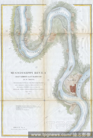
Editorial 1865, U.S.C.S. Chart or Map of the Mississippi River around Cairo Illinois.
- 2019-01-23
- 3

Editorial 1852, U.S.C.S. Map or Chart of Nantucket, Massachusetts.
- 2019-01-23
- 1

Editorial 1857, U.S. Coast Survey Map or Chart of the Rappahannock River, Virginia.
- 2019-01-23
- 1
Editorial 1834, S.D.U.K. Comparative Map or Chart of the World's Great Rivers.
- 2019-01-23
- 1

Editorial 1859, U.S. Coast Survey Map or Nautical Chart of the Florida Keys and Key West.
- 2019-01-23
- 1
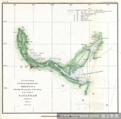
Editorial 1854, U.S. Coast Survey Chart or Map of the Savannah River ans Savannah, Georgia.
- 2019-01-23
- 1

Editorial 1838, Monin Map or Physical Tableau and Astronomy Chart, Zodiac.
- 2019-01-23
- 1

Editorial 1852, U.S. Coast Survey Chart or Map of the Chesapeake Bay and Delaware Bay.
- 2019-01-23
- 1

Editorial 1857, U.S. Coast Survey Map or Chart of the Patapsco River, Chesapeake Bay and Baltimore.
- 2019-01-23
- 1

Editorial 1823, Darton and Gardner Comparative Chart of World Mountains and Rivers.
- 2019-01-23
- 1
Editorial 1850, Andriveau-Goujon Comparative Chart of World Mountains.
- 2019-01-23
- 1
Editorial 1854, U.S. Coast Survey Chart or Map of California and Oregan north of San Francisco.
- 2019-01-23
- 1

Editorial 1864, Justus Perthes Comparative Mountains of the World Chart.
- 2019-01-23
- 1

Editorial 1857, U.S. Coast Survey Chart or Map of the Washington Coast, Puget Sound, Vancouver.
- 2019-01-23
- 1
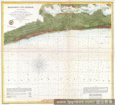
Editorial 1857, U.S. Coast Survey Map or Chart of Mississippi City Harbor, Mississippi.
- 2019-01-23
- 1

Editorial 1650, Jansson Wind Rose, Anemographic Chart, or Map of the Winds.
- 2019-01-23
- 2

Editorial 1859, U.S. Coast Survey Map or Nautical Chart of Crescent City, California.
- 2019-01-23
- 1
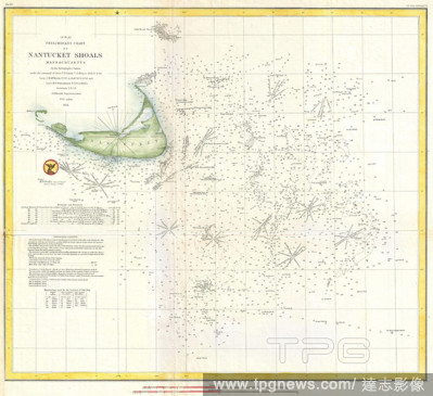
Editorial 1854, U.S. Coast Survey Nautical Chart or Map of Nantucket, Massachusetts.
- 2019-01-23
- 1

Editorial 1873, U.S. Coast Survey Chart of Map of Cape Cod, Nantucket, Marthas Vineyard, and Cape Ann.
- 2019-01-23
- 1
Editorial 1866, U.S. Coast Survey Chart or Map of the Mississippi Sound, Western Part.
- 2019-01-23
- 1

Editorial 1858, U.S.C.S. Map or Chart of Martha's Vineyard or Muskeget Channel.
- 2019-01-23
- 1

Editorial 1866, U.S. Coast Survey Nautical Chart of Charleston Harbor, South Carolina.
- 2019-01-23
- 1

Editorial 1857, U.S. Coast Survey Chart or Map of Chesapeake Bay and Delaware Bay.
- 2019-01-23
- 1

Editorial 1864, U.S.C.S. Chart of the Mississippi River Grand Gulf to New Carthage, Jefferson Davis Plantation.
- 2019-01-23
- 1

Editorial 1855, U.S.C.S. Map or Chart of Washington and Oregon.
- 2019-01-23
- 1

Editorial 1855, Colton Map or Comparative Chart of the World's Islands and Lakes.
- 2019-01-23
- 1

Editorial 1853, U.S.C.S. Map or Chart of Northwestern Washington State, Vancouver Island.
- 2019-01-23
- 1
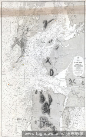
Editorial 1879, British Admiralty Chart or Map of Bombay Harbor, India, Mumbai.
- 2019-01-23
- 1

Editorial 1855, U.S. Coast Survey Chart or Map of Chesapeake Bay and Delaware Bay.
- 2019-01-23
- 1
 Loading