
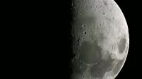
Lunar surface. Animation zooming in to the Mare Orientale Eastern Sea on the Moon磗 surface, starting with a natural colour view and ending with a topographic colour_coded view. The Mare Orientale is a multi_ring basin formed by a massive asteroid impact that then filled with lava. Its position is half on the lunar near side and half on the lunar far side.The colour_coding shows the surface topography, using data gathered by the Lunar Orbiter Laser Altimeter LOLA on the Lunar Reconnaissance Orbiter LRO spacecraft in orbit around the Moon. Surface height is colour_coded, with white areas being the highest elevation, through red, yellow, green and blue, with purple being the lowest elevation. The LRO was launched on 18th June 2009.


Details
WebID:
C00617067
Clip Type:
RM
Super High Res Size:
1920X1080
Duration:
000:13.000
Format:
QuickTime
Bit Rate:
29 fps
Available:
download
Comp:
200X112 (0.00 M)
Model Release:
NO
Property Release
NO
 Loading