
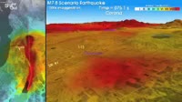
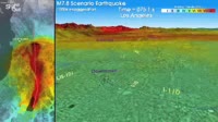
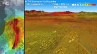
Southern California ShakeOut, earthquake intensity map. These maps model the effect of a magnitude 7.8 earthquake caused by the San Andreas Fault red line. The colours on the land show the intensity of the shaking felt, from orange severe through yellow strong and green moderate to blue weak. The map at left shows the effect on the whole of Southern California. The map at right focuses on Cajon Pass.


Details
WebID:
C00596314
Clip Type:
RM
Super High Res Size:
1920X1080
Duration:
002:29.000
Format:
QuickTime
Bit Rate:
25 fps
Available:
download
Comp:
200X112 (0.00 M)
Model Release:
NO
Property Release
NO
 Loading