
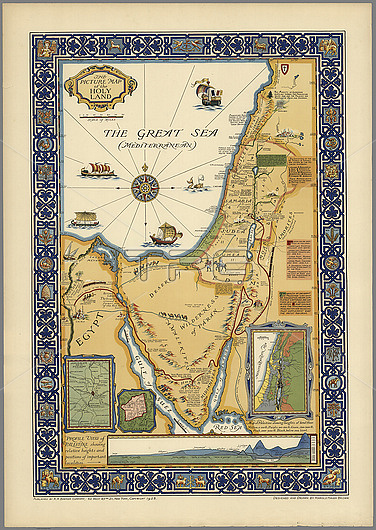
Picture map of the Holy Land, published by R.R. Bowker Company in 1928. The map shows historical boundaries, roads, railway, and places named in the New Testament. It also shows Israel's route to the promised Land in Egypt to the River Jordan, routes used by all who travelled between Egypt and Palestine on the ancient caravan route from Cairo to Mecca. Includes key locations from the biblical narrative, views of sailing ships on The Great Sea (Mediterranean).
| px | px | dpi | = | cm | x | cm | = | MB |
Details
Creative#:
TOP26548281
Source:
達志影像
Authorization Type:
RM
Release Information:
須由TPG 完整授權
Model Release:
N/A
Property Release:
N/A
Right to Privacy:
No
Same folder images:
picturecolorcolourmapholylandHolyLandPalestineIsraelR.R.BowkerCompany1928pictorialframedframedecorateddecorativeborderhistoricalhistoryhistoricboundariesroadsrailwayplacesNewTestamentbiblebiblicalIsrael'sroutepromisedLandEgyptRiverJordanroutestravelledcaravanrouteCairoMeccalocationsnarrativesailingshipsshipTheGreatSeaMediterraneanReliefpictoriallyseaartworkillustration20thecentury1900snobodyno-one
1900s192820theBowkerCairoCompanyEgyptGreatHolyIsraelIsrael'sJordanLandLandMeccaMediterraneanNewPalestineR.R.ReliefRiverSeaTestamentTheartworkbiblebiblicalborderboundariescaravancenturycolorcolourdecorateddecorativeframeframedhistorichistoricalhistoryholylandillustrationlocationsmapnarrativeno-onenobodypictorialpictoriallypictureplacespromisedrailwayroadsrouterouteroutessailingseashipshipstravelled
 Loading