
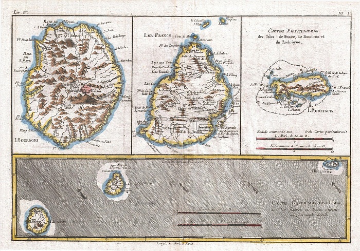
1780, Raynal and Bonne Map of Mascarene Islands, Reunion, Mauritius, Bourbon, Rigobert Bonne 1727 ¡V 1794, one of the most important cartographers of the late 18th century
| px | px | dpi | = | cm | x | cm | = | MB |
Details
Creative#:
TOP29782280
Source:
達志影像
Authorization Type:
RM
Release Information:
須由TPG 完整授權
Model Release:
Not Available
Property Release:
Not Available
Right to Privacy:
No
Same folder images:
1780RaynalandBonneMapofMascareneIslandsReunionMauritiusBourbonRigobertBonne1727¡V1794oneofthemostimportantcartographersofthelate18thcenturytopographycartographygeographylandillustrationgeographictraveltopochartgridlatitudelongitudegeometricatlasmapvintageancienthistoryworldpaperoldretroeartharthistoricaldecorativenavigationagedhistoricjourneydiscoveryexplorationgeographicalMappamundispaceregionoldmapantiquemaprareoldmapsoldantiqueplanolsantiquemapoldantiqueview
17271780179418thBonneBonneBourbonIslandsMapMappaMascareneMauritiusRaynalReunionRigobertagedancientandantiqueantiqueantiqueantiqueartatlascartographerscartographycenturychartdecorativediscoveryearthexplorationgeographicgeographicalgeographygeometricgridhistorichistoricalhistoryillustrationimportantjourneylandlatelatitudelongitudemapmapmapmapmapsmostmundinavigationofofofoldoldoldoldoldolsonepaperplanrareregionretrospacethethetopotopographytravelviewvintageworld¡V
 Loading