
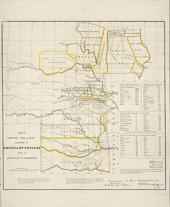
Map showing the lands assigned to emigrant Indians west of Arkansas and Missouri, 1836. Following passage of the Indian Removal Act in 1830, President Andrew Jackson implemented a policy of land exchanges and forced expulsion of the eastern Native Americans to regions west of the Mississippi River. It shows the approximate boundaries of the lands assigned to the relocated tribes in territories west of the Mississippi by 1836. Different shades of color are used to indicate the various tribes. The map also shows the southwestern border of the United States with Mexico, which at that time included the territory that was soon to become the independent Republic of Texas. Forced cession of land by tribes indigenous to the American West, such as the Sioux, is also shown. Approximate geographical boundaries are indicated by rivers, trails, and forts, as territories and states had yet to form in this area. The number of Indians who "emigrated" is listed in the lower right margin, as well as the number of "resident" Indians already living in these regions and the number of Indian tribes remaining east of the Mississippi. Included as well is the total acreage of lands granted by the federal government to the new immigrants according to each tribe.
| px | px | dpi | = | cm | x | cm | = | MB |
Details
Creative#:
TOP29694980
Source:
達志影像
Authorization Type:
RM
Release Information:
須由TPG 完整授權
Model Release:
Not Required
Property Release:
Not Required
Right to Privacy:
No
Same folder images:
 Loading