
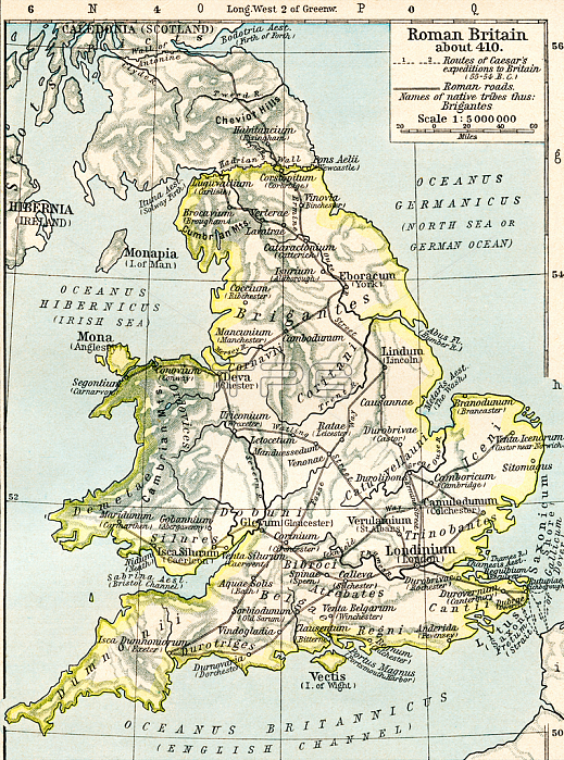
Map of Roman Britain c. 410. From Historical Atlas; published 1923 (print)
| px | px | dpi | = | cm | x | cm | = | MB |
Details
Creative#:
TOP29374411
Source:
達志影像
Authorization Type:
RM
Release Information:
須由TPG 完整授權
Model Release:
no
Property Release:
no
Right to Privacy:
No
Same folder images:
1920s20stwenties1920-19291920's1920s-20s-20s20thcentury20centuryXXcenturyXXthcenturytwentiethcenturyc20th2020thxxxxthtwentiethcentury2020thxxxxthcentury2020th20thXXXXth20thcentury20thearlytwentiethcenturymid-20thcenturyAntiquityantiqueantiquitiescolourcolorcolouredcolorscolourscoloredgeographygeographerUnitedKingdombritishBritainGBUKU.KBritainBritishGreatBritain-Britishbritisch-britischUnitedKngdomAngleterreGrandeBretagneEnglandGreatBritainBritBritonsGreatBritainunitedkingdomofgreatbritainandnorthernirelandukunitedkingdomEuropeeuropeanEuropaemapmapsancientRomeanticromeRomanEmpireromancivilisationnobodyWithoutanyonenopeopleWithoutPeopleunpopulatedprint5thcenturyVthcenturyc5th5th5th5thVVththcentury55thVVthcentury
----1920's1920-19291920s1920s2020202020s20s20s20th20th20th20th20th20th20th55th5th5th5th5thAngleterreAntiquityBretagneBritBritainBritainBritainBritainBritainBritishBritishBritonsEmpireEnglandEuropaeEuropeGBGrandeGreatGreatGreatKingdomKngdomPeopleRomanRomeU.KUKUnitedUnitedVVVthVthVthWithoutWithoutXXXXXXthXXthancientandanticantiqueantiquitiesanyonebritainbritischbritischbritishc20thc5thcenturycenturycenturycenturycenturycenturycenturycenturycenturycenturycenturycenturycenturycenturycivilisationcolorcoloredcolorscolourcolouredcoloursearlyeuropeangeographergeographygreatirelandkingdomkingdommapmapsmid-20thnonobodynorthernofpeopleprintromanromethtwentiestwentiethtwentiethtwentiethukunitedunitedunpopulatedxxxxxxthxxth
 Loading