
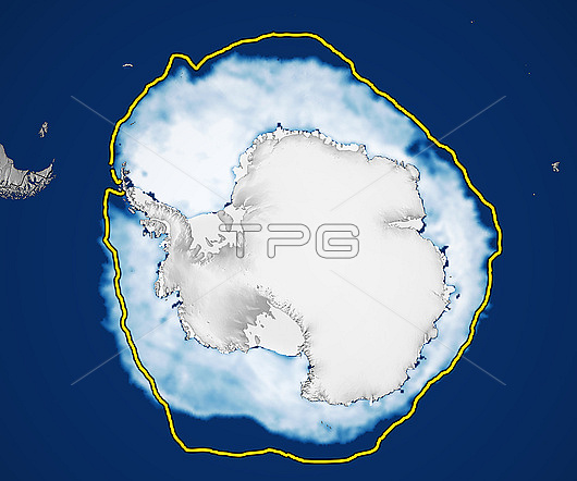
Satellite image showing Antarctic sea ice on 7th August 2023. The yellow line shows the median July ice cover for the years 1981 to 2010. At 13.5 million square kilometres, this was the lowest extent ever recorded at this time of year. This decline follows a downward trend that started after a record high in 2014. The exact mechanism for this decline is not known, although it may be due to heating of the ocean around Antarctica. Data from microwave sensors (SSM/I and SSMIS) on Defense Meteorological Satellite Program (DMSP) satellites and the Scanning Multichannel Microwave Radiometer (SMMR) on the Nimbus-7 satellite.
| px | px | dpi | = | cm | x | cm | = | MB |
Details
Creative#:
TOP29217983
Source:
達志影像
Authorization Type:
RM
Release Information:
須由TPG 完整授權
Model Release:
Not Available
Property Release:
Not Available
Right to Privacy:
No
Same folder images:
 Loading