
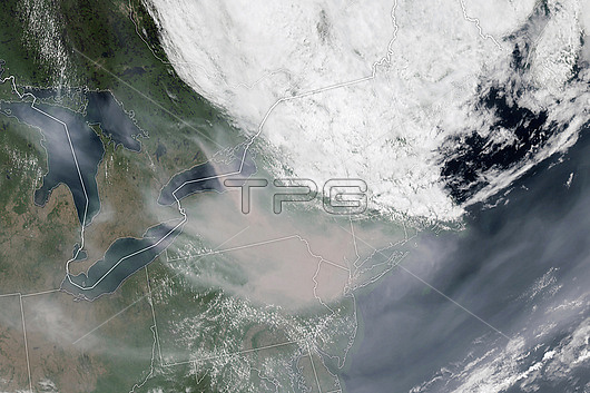
Satellite image of smoke (brown) from wildfires in Quebec, Canada, over New York and Pennsylvania, USA, on 7th June 2023. A coastal low directed the smoke southwards in surface-level air causing the worst smoke-polluted air in the northeastern US states since records began in 2006. At the time hundreds of wildfires were burning across Canada after a heatwave and an abnormally dry spring. Image obtained by the Geostationary Operational Environmental Satellite 16 (GOES-16).
| px | px | dpi | = | cm | x | cm | = | MB |
Details
Creative#:
TOP28995691
Source:
達志影像
Authorization Type:
RM
Release Information:
須由TPG 完整授權
Model Release:
Not Available
Property Release:
Not Available
Right to Privacy:
No
Same folder images:
2000s2020s21stcentury7june2023airairqualityamericanatlanticoceanatmosphereatmosphericburningcanadacanadianclimatechangeclimatecrisisclimateemergencyclimatologicalclimatologycoastcoastalcoastlineearthobservationeasteasternenvironmentenvironmentalsciencefirefiresfromspacegeostationaryoperationalenvironmentalsatellite16globalwarminggoes-16naturaldisasterno-onenobodynorthamericanorthamericannortheasternpollutantpollutingpollutionquebecrecord-breakingsatellitesmokesmoke-pollutedsurface-levelunitedstatesususawildfirewildfireswildfirewildland
2000s21st7162020s2023airairamericaamericanamericanatlanticatmosphereatmosphericburningcanadacanadiancenturychangeclimateclimateclimateclimatologicalclimatologycoastcoastalcoastlinecrisisdisastereartheasteasternemergencyenvironmentenvironmentalenvironmentalfirefirefiresfiresfromgeostationaryglobalgoes-16junenaturalno-onenobodynorthnorthnortheasternobservationoceanoperationalpollutantpollutingpollutionqualityquebecrecord-breakingsatellitesatellitesciencesmokesmoke-pollutedspacestatessurface-levelunitedususawarmingwildwildwildfirewildland
 Loading