
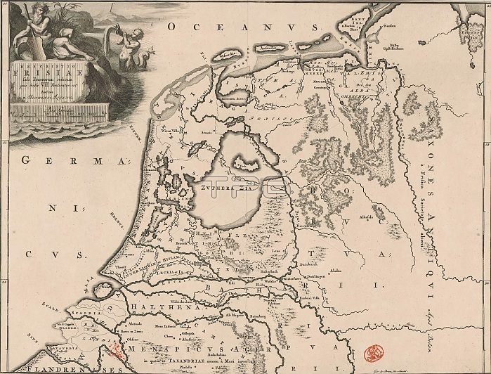
Historical map of the Netherlands with the areas of the Batavians and Frisians, Descriptio Frisiae sub Francorum reditum (...) (title on object), Map of the Netherlands and Germany in Roman times with the area where the Frisians lived. Top left cartouche with title, a river god and a triton. Scale bar below cartouche: Bes gradus. Degrees along left and right edges. print maker: Gerrit de Broen (I), (mentioned on object), Menso Alting, (mentioned on object), Amsterdam, 1697 - 1700 and/or 1725, paper, engraving, etching, height 317 mm x width 417 mm.
| px | px | dpi | = | cm | x | cm | = | MB |
Details
Creative#:
TOP28937950
Source:
達志影像
Authorization Type:
RM
Release Information:
須由TPG 完整授權
Model Release:
No
Property Release:
No
Right to Privacy:
No
Same folder images:
historicalmapnetherlandsareasbataviansfrisiansdescriptiofrisiaesubfrancorumreditumtitleobjectmapnetherlandsgermanyromantimesareafrisianslivedtopleftcartouchetitlerivergodtritonscalebarcartouchebesgradusdegreesleftrightedgesprintmakergerritdebroenimentionedobjectmensoaltingmentionedobjectamsterdam169717001725paperengravingetchingheight317mmxwidth417mm
317417169717001725altingamsterdamareaareasbarbataviansbesbroencartouchecartouchededegreesdescriptioedgesengravingetchingfrancorumfrisiaefrisiansfrisiansgermanygerritgodgradusheighthistoricalileftleftlivedmakermapmapmensomentionedmentionedmmmmnetherlandsnetherlandsobjectobjectobjectpaperprintreditumrightriverromanscalesubtimestitletitletoptritonwidthx
 Loading