
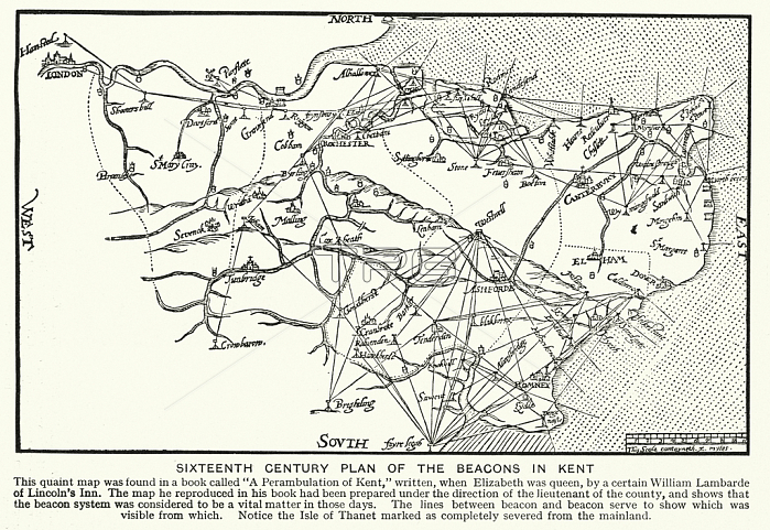
7186556 Sixteenth Century plan of the beacons of Kent (litho) by English School, (20th century); Private Collection; (add.info.: Sixteenth Century plan of the beacons of Kent. Illustration from Wonderful Britain, Its Highways Byways & Historic Places (The Educational Book Co Ltd, London, c1930).); 穢 Look and Learn.
| px | px | dpi | = | cm | x | cm | = | MB |
Details
Creative#:
TOP28712242
Source:
達志影像
Authorization Type:
RM
Release Information:
須由TPG 完整授權
Model Release:
no
Property Release:
no
Right to Privacy:
No
Same folder images:
16thcentury16centuryXVIcenturyXVIthcenturysixteenthcenturyc16th1616thxvixvithcentury20thcentury20centuryXXcenturyXXthcenturytwentiethcentury2020thxxxxthtwentiethcentury2020thxxxxthcentury2020th20thXXXXth20thcenturyc20thearlytwentiethcenturyEnglandenglishEnaglandEngishGreatBritainbritishBritainGBUKUnitedKngdomunitedkingdomBritBritishIslesBritonsEuropeeuropeanEuropenEuropemapcommunicationcommunicationsdrawingdrawingsdraughtsmanillustratingartartsgeographyhistoryhistorichistoricallightlightssignsignpostssignagesignalmapmapsgeneralmapcitymapcityplanstreetplantowertowersKentblackandwhiteblackandwhitebwlithographlithographyillustrationillustrationsbeacons
161616th16th2020202020th20th20th20th20th20thBritBritainBritainBritishBritonsEnaglandEngishEnglandEuropeEuropeEuropenGBGreatIslesKentKngdomUKUnitedXVIXVIthXXXXXXthXXthandartartsbeaconsblackblackandwhitebritishbwc16thc20thcenturycenturycenturycenturycenturycenturycenturycenturycenturycenturycenturycenturycenturycenturycenturycitycitycommunicationcommunicationsdraughtsmandrawingdrawingsearlyenglisheuropeangeneralgeographyhistorichistoricalhistoryillustratingillustrationillustrationskingdomlightlightslithographlithographymapmapmapmapmapsplanplansignsignagesignalsignpostssixteenthstreettowertowerstwentiethtwentiethtwentiethunitedwhitexvixvithxxxxxxthxxth
 Loading