
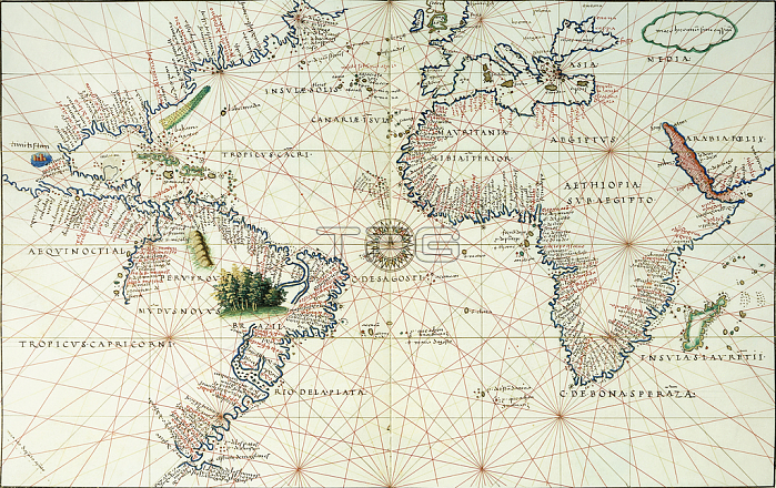
985950 A double-page map of the Atlantic Ocean, showing the east coast of North and South America, 1544 (illuminated manuscript on vellum) by Agnese, Battista (1514-64); 21.8x35 (approx) cm; Private Collection; (add.info.: A double-page map of the Atlantic Ocean, showing the east coast of North and South America. Map 2 from a Portolan Atlas. Battista Agnese (1514-1564). Illuminated manuscript on vellum. Made in Venice circa 1544. 21.8 x 35cm (approx).); Photo 穢 Christie\'s Images.
| px | px | dpi | = | cm | x | cm | = | MB |
Details
Creative#:
TOP27253387
Source:
達志影像
Authorization Type:
RM
Release Information:
須由TPG 完整授權
Model Release:
No
Property Release:
No
Right to Privacy:
No
Same folder images:
coastcoastlineshorelineseamaritimecartographyagnesebattistadoublepagecoastlinenaturalspacenavigationalequipmentshorelineilluminatedmanuscriptchartmanuscripteuropeanartistonvellumnorthamericaoceanitalianartleafitalianartistsouthamericailluminationatlanticleavesgeographicartisteuropeanmapgeographywateratlanticoceandouble-pagepageshoreeastilluminatedatlasportolanagnese1544battistaagnesenavigationagnesebattistadoublepagecoastlinenaturalspacenavigationalequipmentshorelineilluminatedmanuscriptchartmanuscripteuropeanartistonvellumnorthamericaoceanitalianartleafitalianartistsouthamericailluminationatlanticleavesgeographicartisteuropeanmapgeographywateratlanticoceandouble-pagepagecoastalshoreeastilluminatedcoastatlasportolanagnese1544battistaagnesenavigation
15441544agneseagneseagneseagneseagneseagneseamericaamericaamericaamericaartartartistartistartistartistartistartistatlanticatlanticatlanticatlanticatlasatlasbattistabattistabattistabattistacartographychartchartcoastcoastcoastalcoastlinecoastlinecoastlinedoubledoubledouble-pagedouble-pageeasteastequipmentequipmenteuropeaneuropeaneuropeaneuropeangeographicgeographicgeographygeographyilluminatedilluminatedilluminatedilluminatedilluminationilluminationitalianitalianitalianitalianleafleafleavesleavesmanuscriptmanuscriptmanuscriptmanuscriptmapmapmaritimenaturalnaturalnavigationnavigationnavigationalnavigationalnorthnorthoceanoceanoceanoceanononpagepagepagepageportolanportolanseashoreshoreshorelineshorelineshorelinesouthsouthspacespacevellumvellumwaterwater
 Loading