
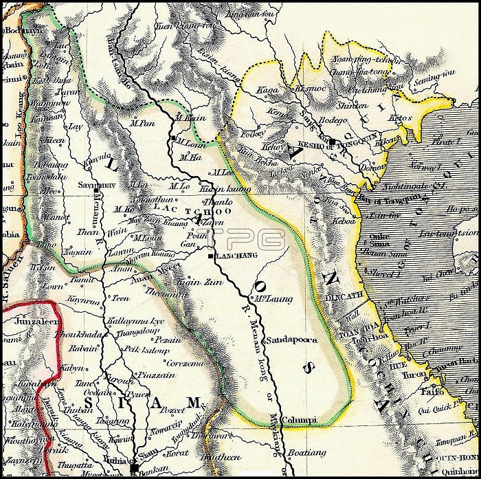
Detail of a British map dating from the early 19th century. Burma's Tenasserim Province (pink) is marked as being British and was seized by Britain after the First Anglo-Burmese War (1824-1826). The geography is very imperfect, the first Brirish surveying teams into 'Laos Land' not being dispatched until the missions of McLeod and Richardson (1836-37). Chiang Mai, the Lan Na capital, at this time under the rule of Chao Phuttawong (1825-46), is identified as 'Saymamay'. The Lao capital, Vientiane, conquered and despoiled by Siam in 1828, is identified as Lanchang, and placed on the wrong, west bank of the Mekong River. Luang Prabang, to the north, is probably identified as (the more northerly) M. Loun. Hanoi, the capital of Tonkin to the Northeast, is identified (puzzlingly) as 'Kesho' or 'Tongquin', the latter being 'Eastern Capital' in Vietnamese. To the south, is still identified as the old capital of Siam, 'Yuthia' (Ayutthaya), although the capital was moved to Bangkok in 1782. The River Salween is shown as the frontier between the Lan Na Kingdom and Burma, while the northernmost part of Lan Na is shown to extend north, into the Shan States in the region of Kengtung.
| px | px | dpi | = | cm | x | cm | = | MB |
Details
Creative#:
TOP27177473
Source:
達志影像
Authorization Type:
RM
Release Information:
須由TPG 完整授權
Model Release:
No
Property Release:
No
Right to Privacy:
No
Same folder images:
 Loading