
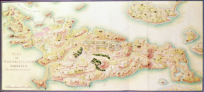
XIR440789 Map of Rhode Island, from \'Guerre de l\'Amerique\', c.1780-81 (colour engraving) by Dubourg, F. (fl.1780-82); Service Historique de la Marine, Vincennes, France; (add.info.: Plan de Rhode-Island; occupied by the French army from 1780-81 on the orders of Jean-Baptiste de Vimeur (1725-1807) Count of Rochambeau;); French, out of copyright.
| px | px | dpi | = | cm | x | cm | = | MB |
Details
Creative#:
TOP27066304
Source:
達志影像
Authorization Type:
RM
Release Information:
須由TPG 完整授權
Model Release:
No
Property Release:
No
Right to Privacy:
No
Same folder images:
coastcoastlineshorelineseamaritimecartographycoastlinearmymilitarycampsrevolutionarywarfrenchamericanwarofindependencerhodeislandoccupationmappingmapamericaoccupieduscampnewportusaEngravingMzengravingcoastlinearmymilitarycampsrevolutionarywarfrenchamericanwarofindependencerhodeislandoccupationmappingmapamericaoccupieduscoastcampnewportusa
EngravingMzengravingamericaamericaamericanamericanarmyarmycampcampcampscampscartographycoastcoastcoastlinecoastlinecoastlinefrenchfrenchindependenceindependenceislandislandmapmapmappingmappingmaritimemilitarymilitarynewportnewportoccupationoccupationoccupiedoccupiedofofrevolutionaryrevolutionaryrhoderhodeseashorelineusususausawarwarwarwar
 Loading