
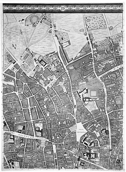
XJF438448 A Map of Clerkenwell, City of London, 1746 (engraving) by Rocque, John (c.1704-d.1762); Private Collection; (add.info.: John Rocque\'s Map of London, 1746, more formally "A plan of the cities of London and Westminster, and borough of Southwark", surveyed by John Rocque and engraved by John Pine, is a map of Georgian London to a scale of 26 inches to a mile.); British, out of copyright.
| px | px | dpi | = | cm | x | cm | = | MB |
Details
Creative#:
TOP27065502
Source:
達志影像
Authorization Type:
RM
Release Information:
須由TPG 完整授權
Model Release:
No
Property Release:
No
Right to Privacy:
No
Same folder images:
capitalcitycitynewgatestreetaldersgatestreetstreetaerialviewgreenhighholbornthenewriverheadgoswellstreetenglandgeorgianareacharterhousesquarebritainbritishstreetsmaphattongardenlondonwestsmithfieldfleetmarketcityoflondonthecityenglishchrist\'shospitalec1bartholomew\'shospitalgray\'sinnlanebartsfinsburyplanclerkenwellbarbicanstcitynewgatestreetaldersgatestreetstreetaerialviewgreenhighholbornthenewriverheadgoswellstreetenglandgeorgianareacharterhousesquarebritainbritishstreetsmaphattongardenlondonwestsmithfieldfleetmarketcityoflondonthecityenglishchrist'shospitalec1bartholomew'shospitalgray'sinnlanebartsfinsburyplanclerkenwellbarbicanst
aerialaerialaldersgatealdersgateareaareabarbicanbarbicanbartholomew'sbartholomew\'sbartsbartsbritainbritainbritishbritishcapitalcharterhousecharterhousechrist'schrist\'scitycitycitycitycitycitycityclerkenwellclerkenwellec1ec1englandenglandenglishenglishfinsburyfinsburyfleetfleetgardengardengeorgiangeorgiangoswellgoswellgray'sgray\'sgreengreenhattonhattonheadheadhighhighholbornholbornhospitalhospitalhospitalhospitalinninnlanelanelondonlondonlondonlondonmapmapmarketmarketnewnewnewgatenewgateofofplanplanriverriversmithfieldsmithfieldsquaresquarestststreetstreetstreetstreetstreetstreetstreetstreetstreetsstreetsthethethetheviewviewwestwest
 Loading