
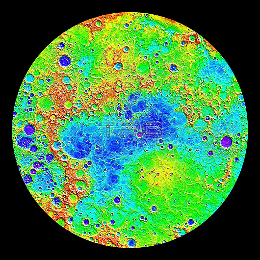
Topography of Mercury, MESSENGER image. During its four-year mission, the MESSENGER (Mercury Surface, Space Environment, Geochemistry, and Ranging) spacecraft mapped the topography of Mercury's northern hemisphere. This relief map shows the lowest regions in purple, and the highest regions in red, with a maximum difference in elevation of around 10 kilometres. Among the prominent features visible here are the smooth northern volcanic plains. The low-lying craters near the north pole contain radar-bright materials, thought to be water ice. Image published in 2015.
| px | px | dpi | = | cm | x | cm | = | MB |
Details
Creative#:
TOP26514127
Source:
達志影像
Authorization Type:
RM
Release Information:
須由TPG 完整授權
Model Release:
N/A
Property Release:
N/A
Right to Privacy:
No
Same folder images:
astronomicalastrophysicalno-onenobodygeophysicsmercurysurfacespaceenvironmentgeochemistryandrangingtopographytopographicreliefmapnorthernhemispheremercurianelevationvolcanicplainsnorthpolepolarnorthernfromspaceblackbackgroundcutoutcut-outcutoutcut-outscutoutscutoutssphericalballglobecircularmercuryplanetsolarsystemspaceastronomyastrophysicsplanetarysciencesatelliteimagemapmessengerspherecircle2015
2015andastronomicalastronomyastrophysicalastrophysicsbackgroundballblackcirclecircularcutcutcut-outcut-outscutoutcutoutselevationenvironmentfromgeochemistrygeophysicsglobehemisphereimagemapmapmercurianmercurymercurymessengerno-onenobodynorthnorthernnorthernoutoutsplainsplanetplanetarypolarpolerangingreliefsatellitesciencesolarspacespacespacespheresphericalsurfacesystemtopographictopographyvolcanic
 Loading