
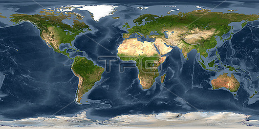
World land and sea floor topography, cylindrical satellite map. The natural colours on land show deserts and vegetation, with mountains ranges also shown. Ocean depth is colour-coded, showing the relatively shallow continental shelves and the deep ocean plains and trenches. The bathymetry data combines satellite observations and ship surveys. The land imagery is from various satellites and digital maps.
| px | px | dpi | = | cm | x | cm | = | MB |
Details
Creative#:
TOP26513510
Source:
達志影像
Authorization Type:
RM
Release Information:
須由TPG 完整授權
Model Release:
N/A
Property Release:
N/A
Right to Privacy:
No
Same folder images:
africaantarcticarcticasiaaustralasiaaustraliabathymetricbathymetrycontinentalcontinentalshelfcontinentscylindricalprojectioneurasiaeuropefromspacegeographicalgeologicalgloballandlandcovermid-oceanridgesmountainrangesmountainsnationaloceanicandatmosphericadministrationno-onenoaanobodynorthamericaoceandepthoceanographicoceansplanetaryrangeridgesseafloorseabedseasshallowshelvessouthamericatopographictopographyunderwatermountainswaterworldworldwideearthplanetregioncontinentoceanseaearthobservationgeographygeologyearthscienceoceanographysatelliteimagesatellite21stcentury
21stadministrationafricaamericaamericaandantarcticarcticasiaatmosphericaustralasiaaustraliabathymetricbathymetrycenturycontinentcontinentalcontinentalcontinentscovercylindricaldeptheartheartheartheurasiaeuropefloorfromgeographicalgeographygeologicalgeologyglobalimagelandlandmid-oceanmountainmountainsmountainsnationalno-onenoaanobodynorthobservationoceanoceanoceanicoceanographicoceanographyoceansplanetplanetaryprojectionrangerangesregionridgesridgessatellitesatellitescienceseaseaseabedseasshallowshelfshelvessouthspacetopographictopographyunderwaterwaterworldworldwide
 Loading