
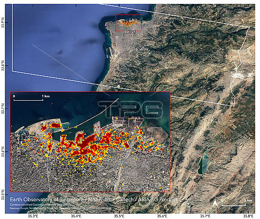
Satellite images of Beirut, Lebanon, showing areas of damage after a large explosion on the 4th August 2020. The most severely damaged areas are red, moderate damage is orange and lesser damaged areas are yellow. Each pixel covers an area of 30 square metres. The explosion occurred after a fire broke out in a warehouse in the city's port that was storing approximately 2,750 tonnes of ammonium nitrate. It was one of the biggest non-nuclear explosions in history and caused at least 220 fatalities and injured over 6,000 people, as well as causing extensive structural damage. Image created by NASA's ARIA (Advanced Rapid Imaging and Analysis) team using Copernicus Sentinel-1A satellite imagery.
| px | px | dpi | = | cm | x | cm | = | MB |
Details
Creative#:
TOP25776433
Source:
達志影像
Authorization Type:
RM
Release Information:
須由TPG 完整授權
Model Release:
N/A
Property Release:
N/A
Right to Privacy:
No
Same folder images:
 Loading