
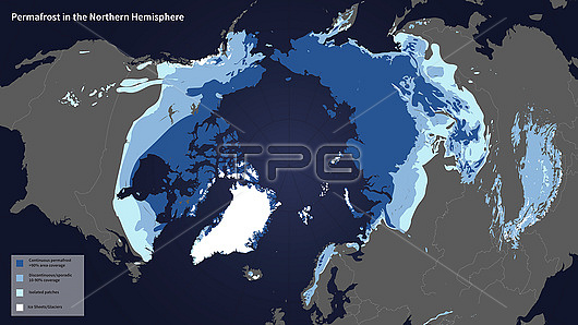
Permafrost map for Earth's northern hemisphere. Permafrost is defined as soil, rock, and any other subsurface Earth material that exists at or below zero degrees Celsius for two or more consecutive years. The colour-coding (key at bottom left) shows areas that are continuous or discontinuous or sporadic permafrost, as well as isolated areas and ice sheets and glaciers. This updated map from 2012 is based on an earlier version from 1997 by the International Permafrost Association. The updating used data from the Soil Moisture Active Passive (SMAP) mission, NASA's first Earth-observing satellite mission designed to collect continuous global observations of surface soil moisture conditions. This research is used to help track trends caused by climate change and global warming. Image published in 2015.
| px | px | dpi | = | cm | x | cm | = | MB |
Details
Creative#:
TOP25529479
Source:
達志影像
Authorization Type:
RM
Release Information:
須由TPG 完整授權
Model Release:
N/A
Property Release:
N/A
Right to Privacy:
No
Same folder images:
 Loading