
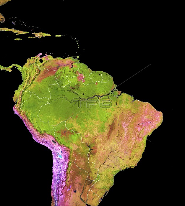
Land cover in and around the Amazon, 2018. Colour-coded map based on satellite data, showing various land cover types in and around the Amazon rainforests. Dense vegetation and rainforest are dark green. Black areas are water. Orange areas are land cleared for pasture. Brown areas are flooded savanna and wetlands. Pink areas are bare ground. Purple areas are deserts and arid areas. Blue-white areas are salt flats. The map is based on images obtained by the Landsat 7 and Landsat 8 satellites.
| px | px | dpi | = | cm | x | cm | = | MB |
Details
Creative#:
TOP25373522
Source:
達志影像
Authorization Type:
RM
Release Information:
須由TPG 完整授權
Model Release:
N/A
Property Release:
N/A
Right to Privacy:
No
Same folder images:
BAREGROUNDBIOMEBIOMESCOLORCODEDCOLOUR-CODEDDEFORESTATIONDESERTSECOLOGICALFIELDSGEOGRAPHICALHABITATHABITATSLATINAMERICANO-ONENOBODYPASTURERAINFORESTRAINFORESTSSALTFLATSTYPETYPESVEGETATIONWETLANDSBLACKBACKGROUNDMAPLANDCOVERSOUTHAMERICAAMAZONBRAZILPERUECUADORCOLOMBIAVENEZUELAGUYANAFRENCHGUYANASURINAMEBOLIVIAEARTHOBSERVATIONGEOGRAPHYENVIRONMENTALSCIENCEECOLOGYSATELLITEIMAGEFROMSPACESATELLITELANDSAT7LANDSAT821STCENTURY2018
201821ST78AMAZONAMERICAAMERICABACKGROUNDBAREBIOMEBIOMESBLACKBOLIVIABRAZILCENTURYCODEDCOLOMBIACOLORCOLOUR-CODEDCOVERSOUTHDEFORESTATIONDESERTSEARTHECOLOGICALECOLOGYECUADORENVIRONMENTALFIELDSFLATSFRENCHFROMGEOGRAPHICALGEOGRAPHYGROUNDGUYANAGUYANAHABITATHABITATSIMAGELANDLANDSATLANDSATLATINMAPNO-ONENOBODYOBSERVATIONPASTUREPERURAINFORESTRAINFORESTSSALTSATELLITESATELLITESCIENCESPACESURINAMETYPETYPESVEGETATIONVENEZUELAWETLANDS
 Loading