
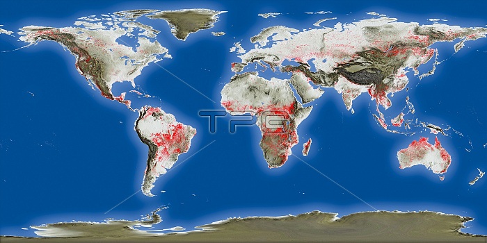
Global fire hot spots from 1996 to 2010, satellite map. These hot spots (including wild fires) were detected by two ESA satellites: ERS-2's Along Track Scanning Radiometer (ATSR-2) and Envisat's Advanced Along Track Scanning Radiometer (AATSR). The date period covered was July 1996 to August 2010. These radiometers measure thermal infrared radiation to take the temperature of Earth's land surfaces. Temperatures exceeding 38.85 degrees Celsius are classified as a fire.
| px | px | dpi | = | cm | x | cm | = | MB |
Details
Creative#:
TOP25373504
Source:
達志影像
Authorization Type:
RM
Release Information:
須由TPG 完整授權
Model Release:
N/A
Property Release:
N/A
Right to Privacy:
No
Same folder images:
NO-ONENOBODYGEOGRAPHICALCLIMATOLOGICALALONGTRACKSCANNINGRADIOMETERADVANCEDALONGTRACKSCANNINGRADIOMETEREUROPEANREMOTE-SENSINGSATELLITEENVIRONMENTALSATELLITECLIMATECHANGE1900SGLOBALWARMINGFIREFIRESWILDFIREWILDFIRESWILDFIRESWILDFIRECYLINDRICALPROJECTIONGLOBALWORLDWIDEPLANETARYWORLDMAPCONTINENTEARTHEARTHOBSERVATIONGEOGRAPHYCLIMATOLOGYSATELLITEMAPFROMSPACESATELLITEATRSAATSRERSENVISAT20THCENTURY21STCENTURY19962010
1900S1996201020TH21STAATSRADVANCEDALONGALONGATRSCENTURYCENTURYCHANGECLIMATECLIMATOLOGICALCLIMATOLOGYCONTINENTEARTHCYLINDRICALEARTHENVIRONMENTALENVISATERSEUROPEANFIREFIREFIRESFIRESFROMGEOGRAPHICALGEOGRAPHYGLOBALGLOBALMAPMAPNO-ONENOBODYOBSERVATIONPLANETARYPROJECTIONRADIOMETERRADIOMETERREMOTE-SENSINGSATELLITESATELLITESATELLITESATELLITESCANNINGSCANNINGSPACETRACKTRACKWARMINGWILDWILDWILDFIREWILDFIRESWORLDWORLDWIDE
 Loading