
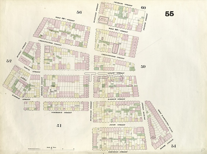
Plate 55: Map bounded by Charles Street, 4th Street, West Washington Place, Sixth Avenue, Cornelia Street, Bleeker Street, Commerce Street, Hudson Street, West 10th Street, Bleeker Street. 1857, 1862, Perris and Browne, New York, USA
| px | px | dpi | = | cm | x | cm | = | MB |
Details
Creative#:
TOP25191089
Source:
達志影像
Authorization Type:
RM
Release Information:
須由TPG 完整授權
Model Release:
No
Property Release:
No
Right to Privacy:
No
Same folder images:
10th185718624th55agedamericaamericanandavenuebleekerbrownecartographiccartographycharlescommercecorneliadrawingdrawingsgeographyhistorichistoricalhistoricallyhistoryhudsonillustrationillustrationsmapnewofoldpaintedpaintingperrispicturepicturesplaceplateplatesroadroadssixthStatesstreetstreetsU.S.AU.S.A.UnitedUSusavintagewashingtonwestyorkalimdiRM333D8FS3
10th18571862333D8FS34th55RMStatesU.S.AU.S.A.USUnitedagedalimdiamericaamericanandavenuebleekerbrownecartographiccartographycharlescommercecorneliadrawingdrawingsgeographyhistorichistoricalhistoricallyhistoryhudsonillustrationillustrationsmapnewofoldpaintedpaintingperrispicturepicturesplaceplateplatesroadroadssixthstreetstreetsusavintagewashingtonwestyork
 Loading