
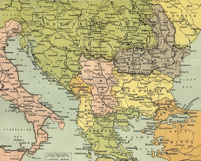
'Map To Illustrate the Eastern Battle Fronts', 1919. Map showing areas of eastern Europe and the Balkans which saw fighting during the First World War, 1914-1919, including Italy, Austria-Hungary, Albania, Montenegro, Greece, Serbia, Bulgaria, Romania, and parts of Russia and Turkey. From "The History of the Great European War: its causes and effects", Vol. V, by W. Stanley Macbean Knight. [Caxton Pulishing Company, Limited, London, 1919]
| px | px | dpi | = | cm | x | cm | = | MB |
Details
Creative#:
TOP24719190
Source:
達志影像
Authorization Type:
RM
Release Information:
須由TPG 完整授權
Model Release:
No
Property Release:
No
Right to Privacy:
No
Same folder images:
EuropeseaItalycoastcountryTurkeycontinentgeographycolorGreeceBalkansAegeanTurkishwarfrontlocationcenturyRussiaBulgariaRomaniafirstworldwarAlbaniaconceptBlackSeaColourWorldWarIWWISerbiaWorldWarOne1910s20thcenturyAdriaticMontenegroThePrintCollector1stWorldWarAustro-HungarianeasternfrontgeographicalfeatureTGNWW1mapAustria-HungaryKnightGeorgePhilip&SonLtdCaxtonPublishingCompanyWilliamStanleyMacbeanKnightWilliamStanleyMacbeanW.StanleyMacbeanKnightWStanleyMacbeanKnightW.StanleyMacbeanWStanleyMacbeanW.S.M.W.S.M.KnightCaxtonPulishingCompanyLimGeorgePhilip&SonPhilipGeorge&SonLtd
&&&1910s1st20thAdriaticAegeanAlbaniaAustria-HungaryAustro-HungarianBalkansBlackBulgariaCaxtonCaxtonCollectorColourCompanyCompanyEuropeGeorgeGeorgeGeorgeGreeceIItalyKnightKnightKnightKnightKnightLimLtdLtdM.M.MacbeanMacbeanMacbeanMacbeanMacbeanMacbeanMontenegroOnePhilipPhilipPhilipPrintPublishingPulishingRomaniaRussiaS.S.SeaSerbiaSonSonSonStanleyStanleyStanleyStanleyStanleyStanleyTGNTheTurkeyTurkishWWW.W.W.W.WW1WWIWarWarWarWilliamWilliamWorldWorldWorldcenturycenturycoastcolorconceptcontinentcountryeasternfeaturefirstfrontfrontgeographicalgeographylocationmapseawarwarworld
 Loading