
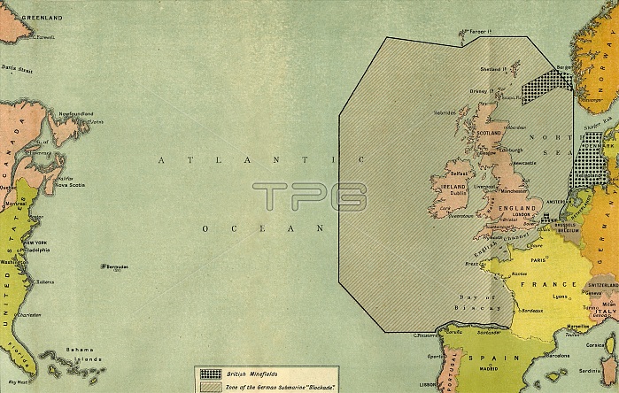
'Map To Illustrate the German Submarine Blockade and the British Minefields as a Measure of Protection', 1919. Map of the Atlantic Ocean during the First World War, 1914-1919, showing part of the east coast of the United States, Great Britain and western Europe. From "The History of the Great European War: its causes and effects", Vol. VII, by W. Stanley Macbean Knight. [Caxton Pulishing Company, Limited, London, 1919]
| px | px | dpi | = | cm | x | cm | = | MB |
Details
Creative#:
TOP24718986
Source:
達志影像
Authorization Type:
RM
Release Information:
須由TPG 完整授權
Model Release:
No
Property Release:
No
Right to Privacy:
No
Same folder images:
GermanyEuropeoceanGermancountrycontinentBritishcolorAtlanticOceanwarlocationcenturyminesmineBritainfirstworldwarconceptGreatBritainColourWorldWarIWWIblockadeWorldWarOne1910s20thcenturyThePrintCollector1stWorldWarTGNWW1mapKnightCaxtonPublishingCompanyWilliamStanleyMacbeanKnightWilliamStanleyMacbeanW.StanleyMacbeanKnightWStanleyMacbeanKnightW.StanleyMacbeanWStanleyMacbeanW.S.M.W.S.M.KnightCaxtonPulishingCompanyLimLondonGeographicalInstituteminefieldminefields
1910s1st20thAtlanticBritainBritainBritishCaxtonCaxtonCollectorColourCompanyCompanyEuropeGeographicalGermanGermanyGreatIInstituteKnightKnightKnightKnightKnightLimLondonM.M.MacbeanMacbeanMacbeanMacbeanMacbeanMacbeanOceanOnePrintPublishingPulishingS.S.StanleyStanleyStanleyStanleyStanleyStanleyTGNTheWWW.W.W.W.WW1WWIWarWarWarWilliamWilliamWorldWorldWorldblockadecenturycenturycolorconceptcontinentcountryfirstlocationmapmineminefieldminefieldsminesoceanwarwarworld
 Loading