
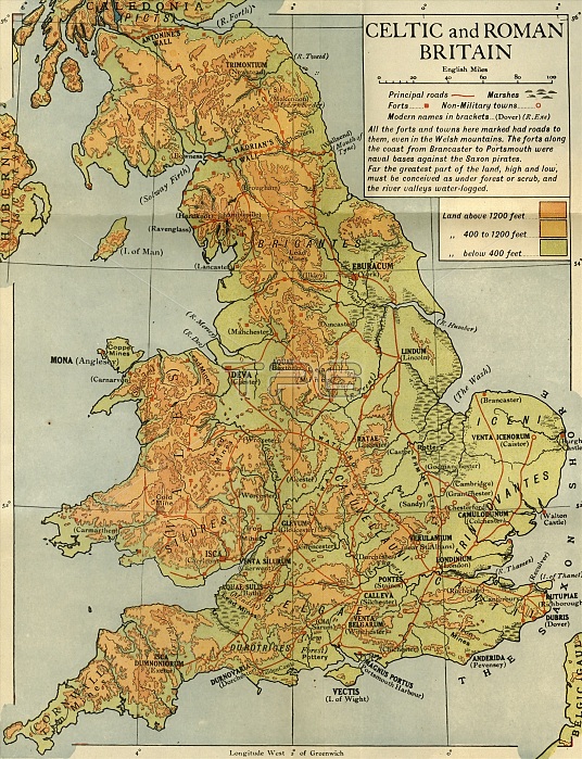
'Celtic and Roman Britain', 1926. Map of Britain during the Roman (43 to 410 AD) and Celtic periods. 'All the forts and towns here marked had roads to them, even in the Welsh mountains. The forts along the coast from Brancaster to Portsmouth were naval bases against the Saxon pirates. Far the greatest part of the land, high and low, must be conceived as under forest or scrub, and the river valleys water-logged.' From "History of England", by George Macaulay Trevelyan. [Longmans, Green and Co. Ltd, London, 1926]
| px | px | dpi | = | cm | x | cm | = | MB |
Details
Creative#:
TOP24718484
Source:
達志影像
Authorization Type:
RM
Release Information:
須由TPG 完整授權
Model Release:
No
Property Release:
No
Right to Privacy:
No
Same folder images:
roadroadsItalybuildingEnglandfortfortsartsWalescountryRomecoastlinebookoccupationgeographycolorlaneavenuefortificationRomanlocationcenturynetworkcartographyliteratureCeltictwentiesColour1920s20thcenturyAntonineWallHadrian'sWallThePrintCollectormap-makingRomanBritainRomanEmpirestreetmapWalker&BoutallLongman&CoEmeryWalkerLtdoccupiedterritoryHistoryofEnglandLongmanRoberts&GreenAntonine'sWallWalkerEmeryLtdEmeryWalkerLimitedBoutallWalker&Walker&CockerellCockerellWalker&GeorgeMacaulayTrevelyanTrevelyanGeorgeMacaulayLongmansGreenandCo
&&&&&&1920s20thAntonineAntonine'sBoutallBoutallBritainCelticCoCoCockerellCockerellCollectorColourEmeryEmeryEmeryEmpireEnglandEnglandGeorgeGeorgeGreenGreenHadrian'sHistoryItalyLimitedLongmanLongmanLongmansLtdLtdMacaulayMacaulayPrintRobertsRomanRomanRomanRomeTheTrevelyanTrevelyanWalesWalkerWalkerWalkerWalkerWalkerWalkerWalkerWallWallWallandartsavenuebookbuildingcartographycenturycenturycoastlinecolorcountryfortfortificationfortsgeographylaneliteraturelocationmapmap-makingnetworkoccupationoccupiedofroadroadsstreetterritorytwenties
 Loading