
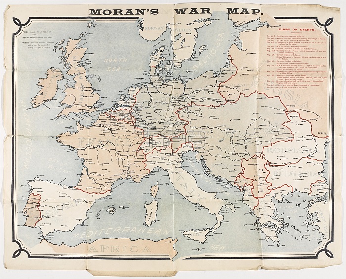
Map: Moran's War Map, coloured to show Britain and her Allies, Germany and Austria-Hungary, and the neutral nations at the outbreak of the First World War. Created by E Moran and Sons Limited, Sunderland;. Belonged to Pte J Harrison (4308), 3rd Division British Expeditionary Force. Includes notes on the key events from 23 Jul to 12 Aug 1914 which lead to the outbreak of War. Associated with World War One, Outbreak of War (1914).
| px | px | dpi | = | cm | x | cm | = | MB |
Details
Creative#:
TOP23968923
Source:
達志影像
Authorization Type:
RM
Release Information:
須由TPG 完整授權
Model Release:
No
Property Release:
No
Right to Privacy:
No
Same folder images:
mapmoran'swarcolouredshowbritainheralliesgermanyaustriahungaryneutralnationsoutbreakfirstworldcreatedemoransonslimitedsunderlandbelongedptejharrison43083rddivisionbritishexpeditionaryforceincludesnoteskeyevents23jul12aug1914leadassociatedone1stgreatww1wwieuropetheofandtowithonatbyfromwhichhistoryhistorical
121st2319143rd4308alliesandassociatedataugaustriabelongedbritainbritishbycolouredcreateddivisioneeuropeeventsexpeditionaryfirstforcefromgermanygreatharrisonherhistoricalhistoryhungaryincludesjjulkeyleadlimitedmapmoranmoran'snationsneutralnotesofononeoutbreakpteshowsonssunderlandthetowarwhichwithworldww1wwi
 Loading