
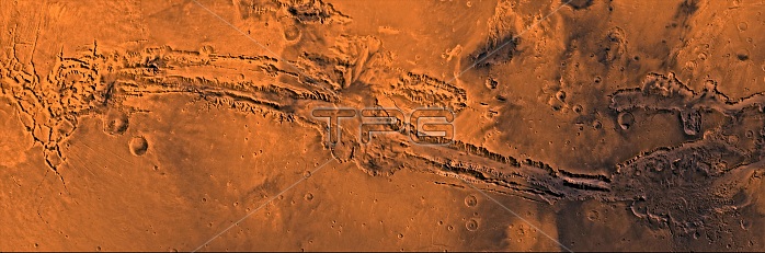
A color, mosaic image taken by the Viking I and II space probes showing the vast system of canyons known as Valles Marineris. These canyons are just south of the martian equator and extend for a length of about 4000 km. Depths range from 2 km to over 7 km in its central section where the canyons merge to create a chasm (center) 600 km wide. The canyons appear to have formed mainly by erosion and faulting. Layers of material in the eastern canyons might consist of carbonates deposited in ancient lakes, eolian deposits, or volcanic materials. Huge ancient river channels began from Valles Marineris and from adjacent canyons and ran north. Many of the channels flowed north into Chryse Basin. Viking I and II were launched in August and September 1975 respectively. They both landed on the martian surface in the following year.
| px | px | dpi | = | cm | x | cm | = | MB |
Details
Creative#:
TOP22309623
Source:
達志影像
Authorization Type:
RM
Release Information:
須由TPG 完整授權
Model Release:
N/A
Property Release:
No
Right to Privacy:
No
Same folder images:
 Loading