
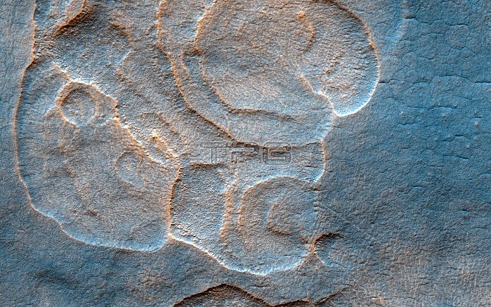
Scalloped landscape on Mars, satellite image. This image shows part of the western Utopia Planitia region on Mars. These scalloped depressions probably form by removal of ice-rich subsurface material by sublimation. This is a similar process to permafrost polygons that form on Earth. These landforms most likely show that sub-surface ice is present or has been present geologically recently. These observations were made by the High Resolution Imaging Science Experiment (HiRISE) camera on NASA's Mars Reconnaissance Orbiter spacecraft. Image published in 2017.
| px | px | dpi | = | cm | x | cm | = | MB |
Details
Creative#:
TOP20028326
Source:
達志影像
Authorization Type:
RM
Release Information:
須由TPG 完整授權
Model Release:
N/A
Property Release:
N/A
Right to Privacy:
No
Same folder images:
NO-ONENOBODYMARTIANHIGHRESOLUTIONIMAGINGSCIENCEEXPERIMENTMARSRECONNAISSANCEORBITERGEOLOGICALFROMSPACEEROSIONFLOWFEATUREFEATURESSCALLOPEDSCALLOPSUTOPIAPLANITIASUBLIMATIONPERMAFROSTPOLYGONSPOLYGONALWATERFLOWICEARIDDESERTWORLDLANDSCAPEMARSPLANETSURFACESPACESOLARSYSTEMPLANETARYSCIENCEGEOLOGYAREOLOGYSATELLITEIMAGEHIRISEMROSATELLITE21STCENTURY2017
201721STAREOLOGYARIDCENTURYDESERTEROSIONEXPERIMENTFEATUREFEATURESFLOWFLOWFROMGEOLOGICALGEOLOGYHIGHHIRISEICEIMAGEIMAGINGLANDSCAPEMARSMARSMARTIANMRONO-ONENOBODYORBITERPERMAFROSTPLANETPLANETARYPLANITIAPOLYGONALPOLYGONSRECONNAISSANCERESOLUTIONSATELLITESATELLITESCALLOPEDSCALLOPSSCIENCESCIENCESOLARSPACESPACESUBLIMATIONSURFACESYSTEMUTOPIAWATERWORLD
 Loading