
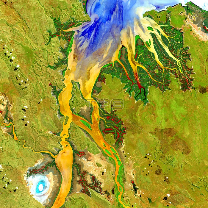
Ord River estuary, satellite image. Mangroves (dark green) grow along the banks of the Ord River in the Kimberley region of Western Australia. Yellow, orange, and blue colours indicate the flow patterns of sediment and nutrients in this tropical estuary. The bright spot at lower left is an area of mudflats, home to saltwater crocodiles. Image data obtained by the Landsat 8 satellite on 12 May 2013.
| px | px | dpi | = | cm | x | cm | = | MB |
Details
Creative#:
TOP19653145
Source:
達志影像
Authorization Type:
RM
Release Information:
須由TPG 完整授權
Model Release:
N/A
Property Release:
N/A
Right to Privacy:
No
Same folder images:
FROMSPACEGEOGRAPHICALNO-ONENOBODYCOASTCOASTALRIVERSRIVERINEMANGROVESFORESTSECOLOGICALAUSTRALIANESTUARINESEDIMENTSMUDFLATSESTUARYRIVERWATERWAYWATERLANDMANGROVEFORESTAUSTRALIAKIMBERLEYWESTERNAUSTRALIAGEOGRAPHYEARTHOBSERVATIONPHYSICALGEOGRAPHYECOLOGYSATELLITEIMAGESATELLITELANDSATLANDSAT821STCENTURY201312MAY2013
8122013201321STAUSTRALIAAUSTRALIANCENTURYCOASTCOASTALEARTHECOLOGICALECOLOGYESTUARINEESTUARYFORESTAUSTRALIAFORESTSFROMGEOGRAPHICALGEOGRAPHYGEOGRAPHYIMAGEKIMBERLEYLANDLANDSATLANDSATMANGROVEMANGROVESMAYMUDFLATSNO-ONENOBODYOBSERVATIONPHYSICALRIVERRIVERINERIVERSSATELLITESATELLITESEDIMENTSSPACEWATERWATERWAYWESTERN
 Loading