
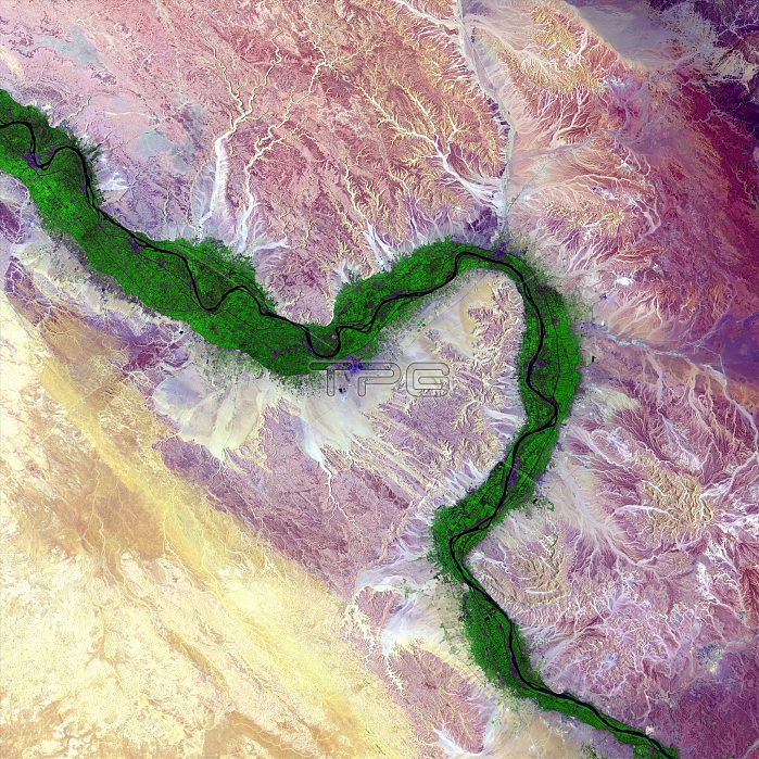
Nile and Egyptian desert, satellite image. Along the Nile River in Egypt, farmland (green) is maintained on the river's floodplain in stark contrast to the surrounding arid desert. The ability to farm along this river has sustained civilisations in this area for thousands of years. This region of the river includes the city of Luxor and many of the famed structures and buildings of Ancient Egypt. Image data obtained by the Landsat 8 satellite on 15 August 2014.
| px | px | dpi | = | cm | x | cm | = | MB |
Details
Creative#:
TOP19653139
Source:
達志影像
Authorization Type:
RM
Release Information:
須由TPG 完整授權
Model Release:
N/A
Property Release:
N/A
Right to Privacy:
No
Same folder images:
AFRICANAGRICULTURALCONTRASTEGYPTIANFARMINGFIELDSFROMSPACEGEOGRAPHICALGEOLOGICALIRRIGATEDIRRIGATIONNO-ONENOBODYRIVERINERIVERSVEGETATIONLUXORANCIENTEGYPTRIVERFARMLANDFLOODPLAINWATERWAYSANDROCKAFRICADESERTEGYPTGEOGRAPHYEARTHOBSERVATIONAGRICULTUREGEOLOGYPHYSICALGEOGRAPHYSATELLITEIMAGESATELLITELANDSATLANDSAT821STCENTURY201415AUGUST2014
1521ST820142014AFRICANAGRICULTURALAGRICULTUREANCIENTAUGUSTCENTURYCONTRASTDESERTEARTHEGYPTEGYPTEGYPTIANFARMINGFARMLANDFIELDSFLOODPLAINFROMGEOGRAPHICALGEOGRAPHYGEOGRAPHYGEOLOGICALGEOLOGYIMAGEIRRIGATEDIRRIGATIONLANDSATLANDSATLUXORNO-ONENOBODYOBSERVATIONPHYSICALRIVERRIVERINERIVERSROCKAFRICASANDSATELLITESATELLITESPACEVEGETATIONWATERWAY
 Loading