
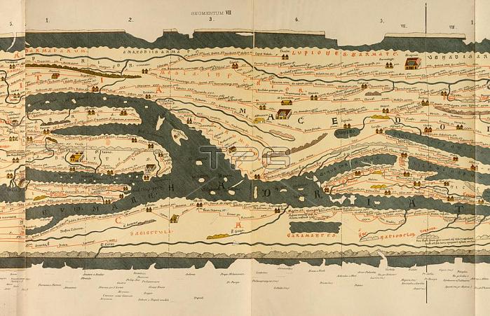
Geography: Maps of the World:Peutinger Table (Map of the Roman Empire; created in 3rd Century AD; copy from 1264); 7th segment: Lower Italy; Sicily; Greece.Colour lithograph.From: Weltkarte des Castorius; genannt die Peutinger'sche Tafel; edited by Konrad Miller; Ravensburg (O.Maier) 1888.Berlin; Museum f黵 Kommunikation.
| px | px | dpi | = | cm | x | cm | = | MB |
Details
Creative#:
TOP17250536
Source:
達志影像
Authorization Type:
RM
Release Information:
須由TPG 完整授權
Model Release:
No
Property Release:
No
Right to Privacy:
No
Same folder images:
13THCENTURY2NDMILLENNIUMA.D.3RDCENTURYADRIAHADRIAANCIENTWORLDANTIQUITYANONYMOUSPERSONBerlinMuseumf黵KommunikationCARTOGRAPHYCDGEOGRAPHYGRAPHICARTGRAPHICARTSGREECEKONRADMILLERLANDSCAPEFORMATLITHOGRAPHLOWERITALYMAPMAKINGMAPOFCASTORIUSMAPOFTHEWORLDWORLDMAPPARTIALVIEWPRINTEDGRAPHICSROADMAPROMANEMPIRESICILYSTREETNETWORKROADNETWORKROADSYSTEMTRAFFICTRANSPORTATION
13TH2ND3RDA.D.ADRIAANCIENTANONYMOUSANTIQUITYARTARTSBerlinCARTOGRAPHYCASTORIUSCDCENTURYCENTURYEMPIREFORMATGEOGRAPHYGRAPHICGRAPHICGRAPHICSGREECEHADRIAITALYKONRADKommunikationLANDSCAPELITHOGRAPHLOWERMAKINGMAPMAPMAPMAPMAPMILLENNIUMMILLERMuseumNETWORKNETWORKOFOFPARTIALPERSONPRINTEDROADROADROADROMANSICILYSTREETSYSTEMTHETRAFFICTRANSPORTATIONVIEWWORLDWORLDWORLDf黵
 Loading