
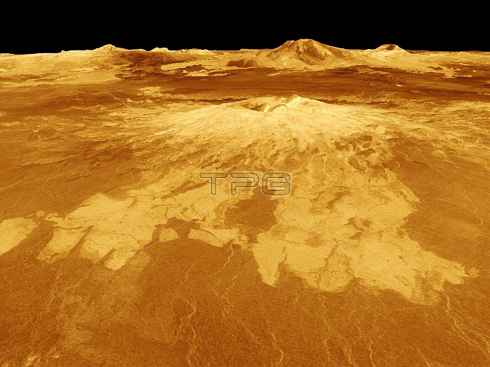
Surface of Venus. 3D computer-generated composite radar image showing the western edge of the Atla Regio area of the surface of Venus. Here, lava flows can be seen extending for hundreds of kilometres across the fractured plains in the foreground to the base of the Sapas Mons (upper centre) volcano, with the Maat Mons volcano (top centre) on the horizon. Image composed of synthetic aperture radar data obtained by the Magellan spacecraft, combined with radar altimetry and ray tracing to simulate a perspective view.
| px | px | dpi | = | cm | x | cm | = | MB |
Details
Creative#:
TOP15439230
Source:
達志影像
Authorization Type:
RM
Release Information:
須由TPG 完整授權
Model Release:
No
Property Release:
No
Right to Privacy:
No
Same folder images:
altimetricastrogeologicalastrogeologyastronomicalastronomyastrophysicalastrophysicsatlaregioblackbackgroundcompositedigitalelevationmapfeaturefeaturesflowsgeologicalgeologyheatedhorizonhotlavaflowmaatmonsmagellanspacecraftmapmoltenrockno-onenobodyperspectiveviewplainplainsplanetplanetaryscienceradaraltimetryraytracingsapasmonssolarsystemspaceobservationsurfacesyntheticapertureradarvenusradarmappervolcanicvolcanovolcanologyvulcanology
altimetricaltimetryapertureastrogeologicalastrogeologyastronomicalastronomyastrophysicalastrophysicsatlabackgroundblackcompositedigitalelevationfeaturefeaturesflowflowsgeologicalgeologyheatedhorizonhotlavamaatmagellanmapmapmappermoltenmonsmonsno-onenobodyobservationperspectiveplainplainsplanetplanetaryradarradarradarrayregiorocksapassciencesolarspacespacecraftsurfacesyntheticsystemtracingvenusviewvolcanicvolcanovolcanologyvulcanology
 Loading