
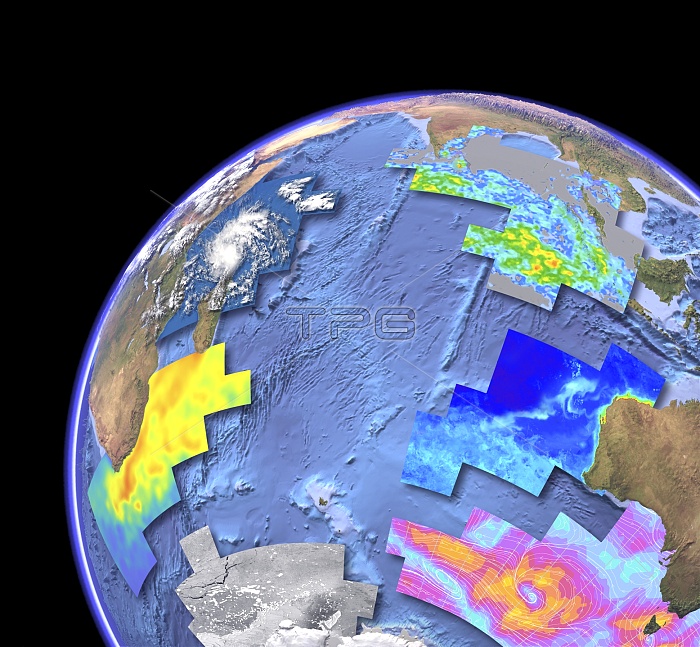
Indian Ocean, satellite imaging data. Computer graphic of the Indian Ocean on an Earth globe, showing the various parameters that can be measured by satellite instruments. Sea floor topography (bathymetry) is from the ERS-1 and Geosat satellites. Other parameters are (clockwise from lower left): sea surface temperature from an infrared radiometer (ATSR on the ERS-1 satellite)
| px | px | dpi | = | cm | x | cm | = | MB |
Details
Creative#:
TOP11247354
Source:
達志影像
Authorization Type:
RM
Release Information:
須由TPG 完整授權
Model Release:
No
Property Release:
No
Right to Privacy:
No
Same folder images:
Restriction:
rainfall from a microwave imager (Tropical Rainfal
INDIANOCEANOCEANSEALANDPARAMETEREARTHGLOBEPLANETEARTHOBSERVATIONPHYSICALGEOGRAPHYEARTHSCIENCEOCEANOGRAPHYMETEOROLOGYBIOLOGYZOOLOGYBOTANYMARINEBIOLOGYSATELLITEIMAGEFROMSPACESATELLITEERS-1GEOSATATSRMODISTERRAAQUATRMMQUICKSCATSARRADARSATMADAGASCARSRILANKATHEMALDIVESTHESEYCHELLESMAURITIUSREUNIONKERGUELENAFRICAASIAAUSTRALIAINDIAINDONESIAMALAYSIAMALAYARCHIPELAGOANTARCTICAANTARCTICISLANDSISLANDCOASTSCOASTALAFRICANASIANAUSTRALIANMARINESEAFLOORSEABEDDEPTHDEPTHSBATHYMETRYBATHYMETRICTOPOGRAPHYTOPOGRAPHICTROPICALRAINFALLMONITORINGMISSIONQUICKSCATTEROMETERMICROWAVESCATTEROMETERCLOUDCOVERINFRAREDRADIOMETERSEASURFACETEMPERATUREANOMALYSEASURFACETEMPERATUREANOMALIESCHLOROPHYLLCONCENTRATIONRAINFALLWINDSPEEDSEAICECOVERRADARSYNTHETICAPERTURERADARMODERATERESOLUTIONIMAGINGSPECTRORADIOMETERADVANCEDALONGTRACKSCANNINGRADIOMETEREUROPEANREMOTESENSINGSATELLITEEUROPEANREMOTESENSING1GEODETICSATELLITEMETEOROLOGICALWEATHERBIOLOGICALZOOLOGICALNATUREFAUNABOTANICALFLORAPARAMETERSASSORTEDRANGECOMPARINGCOMPARISON
1ADVANCEDAFRICAAFRICANALONGANOMALIESANOMALYANTARCTICANTARCTICAAPERTUREAQUAARCHIPELAGOASIAASIANASSORTEDATSRAUSTRALIAAUSTRALIANBATHYMETRICBATHYMETRYBIOLOGICALBIOLOGYBIOLOGYBOTANICALBOTANYCHLOROPHYLLCLOUDCOASTALCOASTSCOMPARINGCOMPARISONCONCENTRATIONCOVERCOVERDEPTHDEPTHSEARTHEARTHEARTHERS-1EUROPEANEUROPEANFAUNAFLOORFLORAFROMGEODETICGEOGRAPHYGEOSATGLOBEICEIMAGEIMAGINGINDIAINDIANINDONESIAINFRAREDISLANDISLANDSKERGUELENLANDLANKAMADAGASCARMALAYMALAYSIAMALDIVESMARINEMARINEMAURITIUSMETEOROLOGICALMETEOROLOGYMICROWAVEMISSIONMODERATEMODISMONITORINGNATUREOBSERVATIONOCEANOCEANOCEANOGRAPHYPARAMETERPARAMETERSPHYSICALPLANETQUICKQUICKSCATRADARRADARRADARSATRADIOMETERRADIOMETERRAINFALLRAINFALLRANGEREMOTEREMOTERESOLUTIONREUNIONSARSATELLITESATELLITESATELLITESATELLITESCANNINGSCATTEROMETERSCATTEROMETERSCIENCESEASEASEASEASEASEABEDSENSINGSENSINGSEYCHELLESSPACESPECTRORADIOMETERSPEEDSRISURFACESURFACESYNTHETICTEMPERATURETEMPERATURETERRATHETHETOPOGRAPHICTOPOGRAPHYTRACKTRMMTROPICALWEATHERWINDZOOLOGICALZOOLOGY
 Loading