
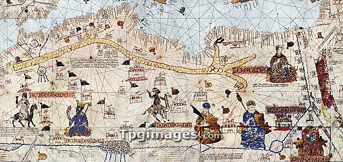
This section of the portolan chart produced in Majorca by Mecia de Viladestes in 1413 shows the trans-Saharan caravan routes from the North African coast southwards to the Kingdom of Mali and includes part of West Africa. The River Niger is visible at the bottom of the chart close to the city of Timbuktu, shown here in Catalan as \Tenbuch\". Timbuktu was an important strategic city that lay across these trans-Saharan trade routes between the salt mines of the north and the gold mines of the south, and those of the slave trade. The blue-robed figure with the gold crown near Timbuktu is Kankou Mousa, King of Mali. Catalonia was a trading partner of North Africa and the Arab and Jewish scholars of the important Majorcan cartographic school in Palma produced nautical and overland charts of great precision considering the technical means available at the time."
| px | px | dpi | = | cm | x | cm | = | MB |
Details
Creative#:
TOP06671220
Source:
達志影像
Authorization Type:
RM
Release Information:
須由TPG 完整授權
Model Release:
NO
Property Release:
NO
Right to Privacy:
No
Same folder images:
 Loading