
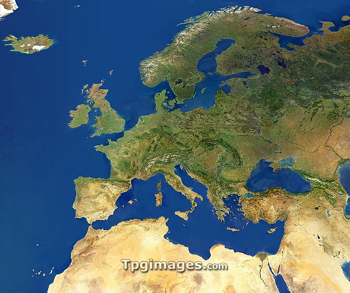
Europe, satellite image. North is at top. This mosaic of cloud-free satellite images shows Europe and the Mediterranean Sea in natural colour from the Atlantic Ocean in the west to the Caspian Sea in the east and from the Sahara Desert in the south to the Arctic Ocean in the north. The data used in this image has been obtained by the MODIS instrument on NASA's Terra satellite.
| px | px | dpi | = | cm | x | cm | = | MB |
Details
Creative#:
TOP06662667
Source:
達志影像
Authorization Type:
RM
Release Information:
須由TPG 完整授權
Model Release:
NO
Property Release:
NO
Right to Privacy:
No
Same folder images:
europecontinentregioneurasiaatlanticoceanmediterraneanseanorthseageographyearthobservationsatelliteimagesatellitemodisterrafromspacegeographicalcontinentalregionaleuropeaneurasiancloud-freecloudfreecloudlessnaturenaturalcolourlandseawatercoastalcoastcoastlinecoastlinesmountainmountainsdesertdesertsariddryicesnowvegetationseasmoderate-resolutionimagingspectroradiometer"
"aridatlanticcloudcloud-freecloudlesscoastcoastalcoastlinecoastlinescolourcontinentcontinentaldesertdesertsdryeartheurasiaeurasianeuropeeuropeanfreefromgeographicalgeographyiceimageimaginglandmediterraneanmoderate-resolutionmodismountainmountainsnaturalnaturenorthobservationoceanregionregionalsatellitesatelliteseaseaseaseassnowspacespectroradiometerterravegetationwater
 Loading