
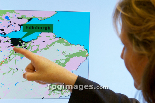
Geoforensic map. Researcher Dr Lorna Dawson pointing at a geoforensic map. This computer generated map shows soil and vegetation type overlaid onto a standard Ordnance Survey map of the region surrounding Edinburgh, UK. It applies data from the chemical analysis of a soil sample and matches it with a geographical database. The map reveals areas where the soil sample matches the soil acidity and clay type (pink), areas where the mineral hornblende is present (red), areas where pine wood and local soil type matches (green). This evidence can be used to trace the movements of a suspect in relation to the crime. The software and database system that generates the geoforensic map is known as SoilFit. Photographed at the Macaulay Institute, Aberdeen, UK.
| px | px | dpi | = | cm | x | cm | = | MB |
Details
Creative#:
TOP03212330
Source:
達志影像
Authorization Type:
RM
Release Information:
須由TPG 完整授權
Model Release:
N/A
Property Release:
N/A
Right to Privacy:
No
Same folder images:
 Loading