
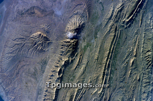
Zagros Mountains, Iran, seen from the International Space Station (ISS). The Zagros Mountains are a range of long linear ridges and valleys formed by the collision of the Asian and Arabian tectonic plates. Subsequent erosion formed the shapes seen here. Features include salt domes (upper centre and upper left) where underground salt left by ancient seas is rising to the surface under the pressure of the overlying rocks, creating a dome structure. Photographed on 28 February 2006 by a member of the ISS's Expedition 12 crew.
| px | px | dpi | = | cm | x | cm | = | MB |
Details
Creative#:
TOP03208324
Source:
達志影像
Authorization Type:
RM
Release Information:
須由TPG 完整授權
Model Release:
N/A
Property Release:
N/A
Right to Privacy:
No
Same folder images:
ZAGROSMOUNTAINSSALTDOMEMOUNTAINRANGEMOUNTAINIRANMIDDLEEASTASIAEARTHOBSERVATIONPHYSICALGEOGRAPHYGEOLOGYFROMSPACEWINTER28-Feb-062006/2/28FEBRUARY200621STCENTURYASIANGEOLOGICALSATELLITEIMAGEEROSIONERODEDROCKROCKYROCKSPLATETECTONICSTECTONICLANDOROGENYOROGENICINTERNATIONALSPACESTATIONEXPEDITION12ISSIRANIANMIDDLEEASTERNSALTDEPOSITSNATUREEARTHORBIT
1220062006/2/2821ST28-Feb-06ASIAASIANCENTURYDEPOSITSDOMEEARTHEARTHEASTEASTERNERODEDEROSIONEXPEDITIONFEBRUARYFROMGEOGRAPHYGEOLOGICALGEOLOGYIMAGEINTERNATIONALIRANIRANIANISSLANDMIDDLEMIDDLEMOUNTAINMOUNTAINMOUNTAINSNATUREOBSERVATIONORBITOROGENICOROGENYPHYSICALPLATERANGEROCKROCKSROCKYSALTSALTSATELLITESPACESPACESTATIONTECTONICTECTONICSWINTERZAGROS
 Loading