
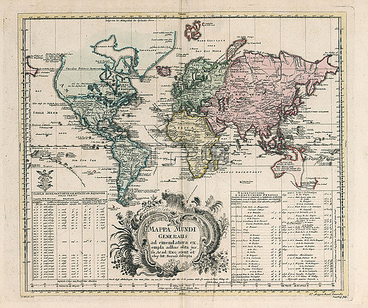
General world map (Mappa Mundi generalis) by Leonhard Euler (1707-1783). Published in 1753 by Ex officina Michaelis, Berolini. Hand coloured copperplate engraving map on 2 sheets. The map shows North America, but the Northwest coast is blank and a river provides passage between the Great Lakes and the Pacific. Australia and New Zealand are depicted with partially completed coastlines. Relief shown pictorially. Prime meridian is Ferro. Includes two large explanation tables.
| px | px | dpi | = | cm | x | cm | = | MB |
Details
Creative#:
TOP26548279
Source:
達志影像
Authorization Type:
RM
Release Information:
須由TPG 完整授權
Model Release:
N/A
Property Release:
N/A
Right to Privacy:
No
Same folder images:
MappaMundigeneralisgeneralmapworldmapoftheworldworldmapcartographyMappaMundigeneralisGeneralworldmapEulerLeonhard175318thcentury1700sHandcoloredhandcolouredcopperplateengravingmapsNorthAmericaAustraliaNewZealandAfricaEuropeAsiaHistoryhistoricalmappamundipictorialmapmakerGeographygeographicalcartographiceartholdartworkillustrationnobodyno-one
1700s175318thAfricaAmericaAsiaAustraliaEulerEuropeGeneralGeographyHandHistoryLeonhardMappaMappaMundiMundiNewNorthZealandartworkcartographiccartographycenturycoloredcolouredcopperplateearthengravinggeneralgeneralisgeneralisgeographicalhandhistoricalillustrationmakermapmapmapmapmapmappamapsmundino-onenobodyofoldpictorialtheworldworldworldworld
 Loading